Killa Abdullah: Where Heritage Meets the Horizon
Killa Abdullah
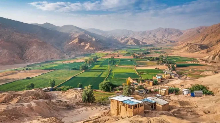
Killa Abdullah, a district located in the western part of Balochistan, Pakistan, holds significant geographical and historical importance. Situated at coordinates 30° 05Ꞌ 07” N latitude and 66° 14Ꞌ 23” E longitude, this district lies in close proximity to the Afghanistan border, making it a gateway between Pakistan and its neighboring country. To the east, it is bordered by the Pishin district, while to the south, it borders Quetta district. The district is primarily known for its rugged terrain, vast mountainous landscapes, and its strategic position in the region.
Historical Background
Killa Abdullah’s name is derived from Abdullah’s Fort, which was built during the early 19th century by Sardar Abdullah Khan, an influential tribal chief of the Achakzai tribe. The fort, also known as Abdullah’s Fort, was established to secure the area against external threats and served as a landmark in the region. The fort itself was a focal point of defense during the Kabul Rebellion of 1841, which saw the British Envoy being killed during a series of violent political uprisings in Afghanistan. This historic event added to the significance of Sardar Abdullah Achakzai, whose legacy is deeply embedded in the district’s history.
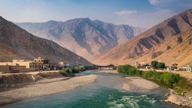
The Achakzais, a prominent tribal group, played a major role in shaping the social and political fabric of Killa Abdullah. As the region’s political landscape evolved, Sardar Abdullah Achakzai emerged as a key figure, contributing to the development of the district’s infrastructure. The karezes, such as Dehsora Karez and Chashma Inzergai, were built by the Achakzai tribe for public use, providing much-needed water to the district. The karezes became an essential part of the district’s irrigation system, helping the people survive in the harsh, arid climate of the region.
Geographical Features
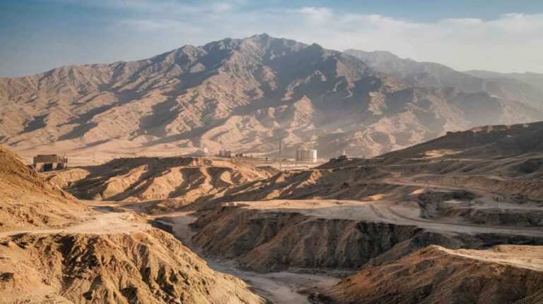
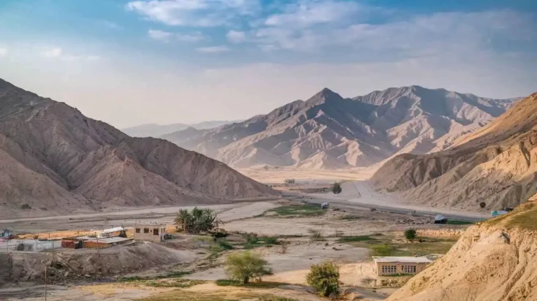
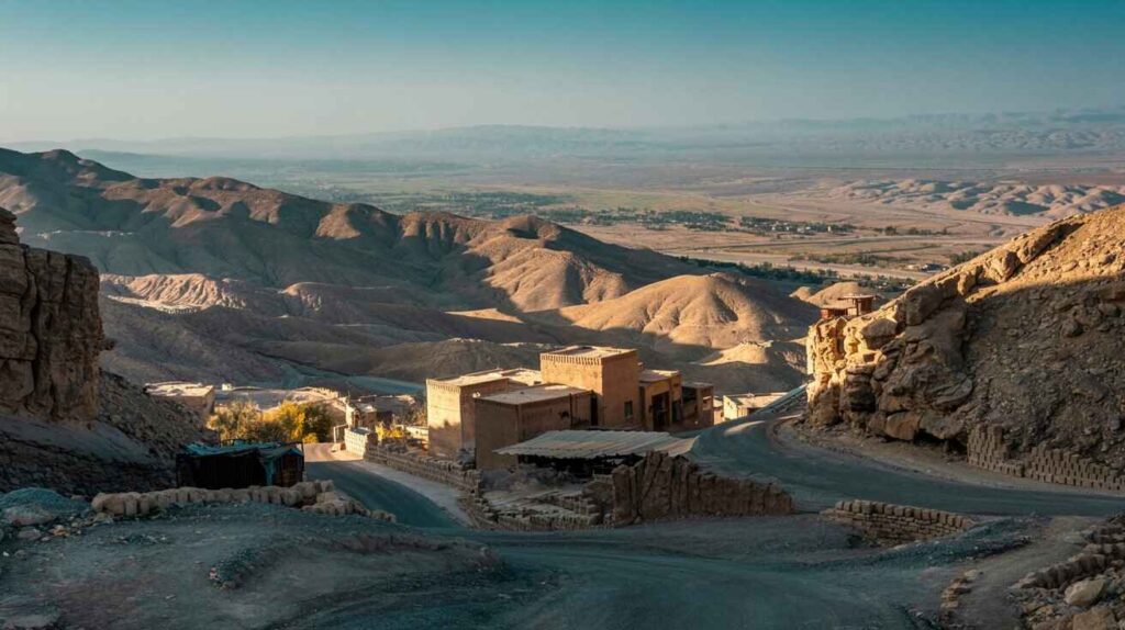
Killa Abdullah’s terrain is characterized by mountainous ranges and narrow valleys that intersect the district. The Toba Kakar Range, stretching along the northern boundary, is the largest mass in the district, followed by the Khwaja Amran and Sarlath ranges, which lie to the south and southeast. The Khwaja Amran Range, with its highest peak at 2,702 meters, is a significant geographical feature, separating Killa Abdullah from Pishin district. The foothills of these mountains are filled with piedmont fans and hill ridges, which further enhance the district’s natural beauty.
The district’s elevation ranges from 1,205 meters to 2,675 meters above mean sea level, providing a diverse topographical landscape. These mountains play an essential role in the region’s climate, creating a microclimate that influences the agricultural practices in the area.
Climate and Seasons
The climate of Killa Abdullah is categorized as warm during the summer months and cold in the winter. The monsoon currents bring scanty and irregular rainfall, with snowfalls occurring in the winter months, particularly from January to February. The district’s mean maximum temperature can reach up to 36°C during the summer months, while the minimum temperature can drop to -3°C in the winter, making it an extreme climate zone. The annual rainfall averages around 260 mm, which is relatively low for the region, contributing to the district’s reliance on irrigation systems such as tube wells and karezes.
Population and Demographics
As of the 2017 census, Killa Abdullah had a population of 757,578 persons, with a growth rate of 4.0%. The population is predominantly Pashtun, with 99.5% Muslims, speaking Pashto as their first language, accounting for 97.5% of the population. Balochi is spoken by 1.6% of the population, while smaller numbers speak Urdu, Punjabi, and Sindhi. The urban population of Killa Abdullah is relatively low, making up only 19.7% of the total population, with the remainder residing in rural areas. The district includes several towns such as Chaman, Gulistan, and Killa Abdullah itself, along with other settlements like Habibzai, Dobundi, and Shela Bagh.
The district’s literacy rate is 27%, with a significant gender disparity in education. The male literacy rate is considerably higher at 42%, while the female literacy rate is 8%. The disparity highlights the need for more educational initiatives to bridge the gap and empower the female population in this region.
Economy and Agriculture
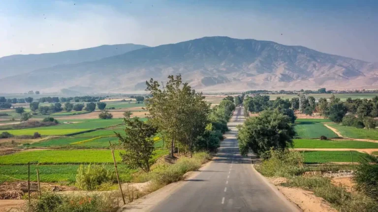
The economy of Killa Abdullah is primarily based on agriculture and livestock breeding. Major crops include wheat, barley, tobacco, sunflower, and alfalfa, while the district also produces a variety of fruits such as watermelon, pomegranate, and apricots. The agricultural activities are heavily dependent on the region’s irrigation network, which includes karezes and tube wells.
Livestock breeding is also a significant economic activity in Killa Abdullah. According to the 2006 census data, the district is home to a wide variety of animals, including cattle, buffaloes, sheep, and goats. The Koh-i-Suleimani breed of cattle, along with sheep breeds like Khurasani, is well-known for its high quality.
Additionally, wholesale and retail trade, along with restaurants and hotels, contribute to about 24.6% of the district’s economy. Construction and community services also form significant components of the economic structure.
Infrastructure and Development
Killa Abdullah’s infrastructure is undergoing gradual development. The district has a metaled road network stretching over 906 km, while the shingle roads extend up to 1,065 km. There are several grid stations managed by the Quetta Electric Supply Company (QESCO), providing electricity to the area. Despite this progress, industrial development remains limited, with only a few flour mills and ice factories operating in the district. The lack of industrial estates is a challenge to the region’s growth and development.
The region’s telecommunications infrastructure includes 252 landlines, 752 wireless phone connections, and 214 broadband connections, facilitating better communication for businesses and individuals alike.
Challenges and Opportunities
Despite its natural beauty and strategic location, Killa Abdullah faces several challenges. The lack of industrial estates, coupled with limited educational opportunities and healthcare services, hinders the district’s progress. However, the vast agricultural land, access to key mountain passes like the Khojak Pass, and proximity to Afghanistan present significant opportunities for economic growth.
As the district continues to develop its infrastructure, there is potential for expanding agricultural exports, especially fruits and livestock, to foreign markets. Additionally, the development of tourism around historical sites such as Abdullah’s Fort and the natural beauty of the Toba Kakar Range could contribute significantly to the local economy.
Killa Abdullah, a district located in the northwestern part of Balochistan province, Pakistan, has seen considerable developments and challenges over the years. This region, which was separated from Pishin District in June 1993, has become an important area for understanding trade, economic growth, and local customs. With its proximity to the Afghanistan border, Killa Abdullah serves as a crucial transit point between Pakistan and Afghanistan. It plays a significant role in the direct trade route, fostering both legal trade and illegal trade between the two countries.
The district has its own distinct history, shaped by the presence of Pashtun tribes such as the Tareen, Kakar, and Achakzai tribes. The population primarily speaks Pashto, and the region is known for its traditional customs, handicrafts, and a strong sense of local identity. These tribes, historically, have formed the backbone of the social and cultural life in Killa Abdullah.
Trade and Economic Development in Killa Abdullah
One of the key economic pillars of Killa Abdullah is its strategic location along the direct trade route to Afghanistan. As a district that bridges Pakistan and Afghanistan, it is a major hub for trade. This district sees an active flow of goods like fresh fruit, dried fruit, timber, cotton, sheep skins, and goat skins. The region’s connection to Chaman, a town on the border, further enhances its role in the transit trade. Additionally, Killa Abdullah benefits from trade with India through the broader regional connections, making it a focal point for commerce in the southwestern region.
However, the district also faces challenges with illegal trade and smuggling, which can disrupt the formal economy. Despite these issues, the local authorities continue to strengthen regulatory frameworks to promote legal trade, focusing on enhancing connectivity and improving local infrastructure.
The local economic infrastructure is a major contributor to the district’s prosperity. The roads and railways, including the vital National Highway N-25 and RCD Highway, link Killa Abdullah to Karachi and other major cities, thus facilitating trade and commerce. These roads, along with a railway line and the Khojak Tunnel, enable the smooth movement of goods across the border.
Handicrafts and Local Artistry
Handicrafts from Killa Abdullah reflect the region’s deep-rooted cultural heritage. The embroidery work here is highly regarded, especially for children’s dresses, women’s dresses, caps, bed covers, pillow covers, and shawls. Local artisans also create rugs, sweaters, and other textiles using sheep’s wool, showcasing the skills passed down through generations. These crafts are often made using wool from the sheep reared in the region, which adds a unique touch to the products.
The handicrafts are not only important culturally but also economically. The sale of local textiles and wool products helps provide a livelihood for many families in Killa Abdullah, especially women who are involved in creating these beautiful, intricate designs. This handicraft industry also helps preserve traditional skills, offering a glimpse into the artistic richness of the district.
Road Infrastructure and Connectivity
The roads in Killa Abdullah are essential for maintaining the district’s connectivity with the rest of Balochistan and the broader national landscape. According to the Balochistan Development Statistics 2018-19, Killa Abdullah has 1,971 km of roads, with 906.0 km classified as high-type roads and 1,065.0 km as low-type roads. The roads that connect Chaman to other parts of Balochistan—like the Quetta-Yaru, Maizai-Chaman-Kandahar, and Gulistan-Huramzai-Pishin roads—play a crucial role in trade, commuting, and access to basic services.
The National Highway N-25 serves as a vital link between Karachi and Chaman, facilitating movement not only within Pakistan but also to the Afghan border. This highway significantly impacts the transportation sector, contributing to the district’s economic growth. Moreover, Killa Abdullah-Dub Khanozai Road and other smaller routes ensure that even remote areas of the district remain accessible.
Rail and Airways Infrastructure
Rail and air transport also form part of Killa Abdullah’s infrastructure. The Khojak Tunnel, located on the border between Pakistan and Afghanistan, connects Killa Abdullah with Chaman and beyond. This strategic railway connection plays an essential role in moving goods and passengers between the two countries. The district has two railway stations, further bolstering its position as a significant commercial hub.
Additionally, Killa Abdullah benefits from air transport through the Quetta International Airport, which serves as a gateway to both local and international destinations. Though there is no commercial airport within Killa Abdullah, its proximity to Quetta means that residents can easily access air travel, making it a crucial component of the region’s connectivity.
Telecommunication and Broadcasting
Telecommunication services in Killa Abdullah have improved significantly in recent years. With cellular phone services and digital telephone exchanges, residents have better access to communication channels. The district is equipped with six telephone exchanges and more than 2000 landlines, which serve the needs of local businesses, residents, and government offices.
In terms of broadcasting, Killa Abdullah has access to radio and television programs from both Karachi and Quetta, as well as from Zahidan and Kabul. The district receives signals for both TV and radio, ensuring that the local population stays informed about national and international news. This access to broadcasting stations helps in fostering a sense of community and awareness.
Education and Healthcare in Killa Abdullah
The education system in Killa Abdullah is expanding, with a variety of schools available across the district. According to the Balochistan Development Statistics 2018-19, there are 415 primary schools, 40 middle schools, and 31 high schools. The district is striving to improve educational access, with a notable focus on gender equality. Although the enrolment rate for girls is lower than that for boys, efforts are underway to improve educational opportunities for girls in both urban and rural areas.
Healthcare facilities in the district include government-run hospitals, basic health units (BHUs), and rural health centers (RHCs). However, there remains a gap in access to specialized medical care, particularly in remote areas. As the population grows, the demand for more comprehensive healthcare services will only increase.
History of Killa Abdullah: A Rich Tapestry of Cultural Evolution and Political Shifts
Early Beginnings and Tribal Origins
The history of Killa Abdullah is deeply rooted in the legacy of various tribes that have inhabited the region for centuries. Located at the strategic crossroads of Afghanistan and Pakistan, it forms part of Baluchistan, a land that has witnessed the rise and fall of empires and the migration of countless tribes. The Tareen tribe, one of the most significant in the area, traces its origins to Afghanistan. Historically, the Tareen people were known to be part of the larger Pashtun confederacy, which contributed significantly to the cultural and political structure of the region.
The Tareen tribe itself is divided into several branches. Among the major ones are the Tor, Spin, and Awdal clans, with the Tareen people further spreading out into different regions, including Pishin, Kakar, and parts of Khyber Pakhtunkhwa. They were native to lands stretching from northern Balochistan to the heart of Afghanistan, specifically Herat and Qais Abdul Rashid. Their ancestors were known as Pashtuns, descendants of the great Qais Abdul Rashid, who united various groups into the confederation that shaped the region’s early identity.
The Mughal Influence and Tribal Rivalries
In the 17th century, the area now known as Killa Abdullah came under the sway of the Mughal emperor Shah Jahan. Between 1628 and 1658, during the Mughal Empire’s zenith, the region witnessed significant development. However, by the time of the Sikh occupation, the Tareen and other local tribes had to navigate new political dynamics that would shift the balance of power. The Sikh armies invaded parts of Baluchistan, leading to a series of conflicts over land and properties. As a result, many tribal leaders, including the Tareen, were forced to emigrate from their ancestral lands, finding refuge in surrounding areas, such as the Khyber Pakhtunkhwa region, while others sought solace in Afghanistan.
Despite the Sikh occupation, the cultural identity of the tribes in Killa Abdullah remained intact. The Tareen tribe, in particular, maintained its influence, with several of its chiefs playing significant roles in the socio-political landscape of Baluchistan. The tribes’ legacy would eventually serve as a foundational element in the future developments of the district, particularly as the region transitioned from being a contested frontier to a part of modern-day Pakistan.
Colonial Influence and Political Transition
In the mid-19th century, the British Empire expanded its influence in the region, marking the beginning of a new chapter in the history of Killa Abdullah. Following the First Anglo-Afghan War (1839–1842), British Indian forces took control of Quetta, Pishin, and surrounding areas, including the land that would become Killa Abdullah. The British, realizing the strategic importance of this territory as a gateway to Afghanistan and Central Asia, established military outposts and administrative units to govern the region.
The British presence brought about significant changes. During their rule, the British Government conducted a survey of the region’s resources, identifying Killa Abdullah as an important military and trade post. At the same time, Baloch tribes such as the Kakars, Marri, and Achakzai had to negotiate their position under colonial rule. The Kakars, for example, were well-known in the area and had historical ties with the Durrani rulers of Afghanistan.
The British-led Indian forces faced resistance from local Pashtun tribes, including the Kakar and Tareen, who resisted British expansion and domination. These tribes had fought against foreign invaders for centuries, and their anti-colonial resistance helped shape the political landscape of the region. After several battles and the eventual defeat of the British Indian Army, the territories surrounding Killa Abdullah became integrated into the British Raj and were part of the larger Balochistan region within British India.
The Emergence of Modern Killa Abdullah
After the Independence of Pakistan in 1947, the region witnessed significant administrative changes. Killa Abdullah became part of Balochistan province. The district’s boundaries were redefined, and it became a vital region for both trade and agriculture. The Killa Abdullah district, particularly Chaman, became one of the most significant border towns, acting as a gateway for trade between Afghanistan and Pakistan.
The Killa Abdullah region, which had long been a melting pot of different cultures and tribes, gradually evolved into a more structured administrative unit within Pakistan. However, tribal affiliations still remained strong, with various tribes continuing to dominate the local political scene.
During the post-independence period, the Pashtun tribes, including the Tareen, Achakzai, and Kakar, solidified their political influence. Many notable figures from these tribes, such as Mahmood Khan Achakzai, a key politician, emerged as central figures in Pakhtunkhwa Milli Awami Party. The Achakzai family, in particular, played a pivotal role in shaping the political future of Killa Abdullah and surrounding regions.
Modern-Day Dynamics
Today, Killa Abdullah is a dynamic region, with a population of over 361,000 as of the latest census in 2023. The area is home to a diverse set of tribes, with Pashtun, Baloch, and Hazara groups coexisting. Despite the rich cultural heritage, the area faces challenges such as poverty, child labor, and limited access to education. The education system in Killa Abdullah has struggled to keep pace with the growing population, with gender disparity and low literacy rates being major concerns. However, the region also boasts a growing interest in improving education and addressing the issues of poverty.
In terms of economy, Killa Abdullah is primarily based on agriculture, with crops like wheat, barley, and vegetables being grown. The district is also known for its livestock sector, which contributes significantly to the local economy. The trade between Pakistan and Afghanistan, especially at the Chaman border, remains vital for the region’s economic well-being.
Key Archaeological Sites and Cultural Significance
The history of Killa Abdullah is not only marked by tribal warfare and colonialism but also by rich cultural and archaeological sites. The Khojak Pass, Khwaja Amran Mountains, and Shela Bagh are just a few of the historically significant spots that have shaped the region’s identity. Chaman, the major town in the district, is not only a commercial hub but also a focal point for the region’s cultural exchange. Visitors can explore local shrines and sites of historical importance, including the Khwaja Amran Shrine, a revered location for the local Pashtun people.
Additionally, the Killa Abdullah region has significant religious landmarks, including the Jamia Masjid, where many local tribes come together for worship. These religious centers, along with the tombs and graves of notable tribal figures, serve as important historical markers for the community.
Historical places in killa Abdullah:
Historic Places of Killa Abdullah District: Spin Ghundi Mound, Khwaja Amran Shrine, and Khojak Tunnel/Pass
Killa Abdullah District, a region nestled in the mountainous terrain of northwestern Balochistan, is not only significant for its strategic location near the Afghanistan border but also for its rich historical and cultural legacy. Three of the most prominent historic places in the district are the Spin Ghundi Mound, Khwaja Amran Shrine, and the Khojak Tunnel/Pass, each of which reflects a unique aspect of the area’s diverse heritage.
Spin Ghundi Mound is an archaeological treasure located in the district. This ancient mound is believed to date back thousands of years, with origins possibly tracing to the early Bronze Age or even earlier. Excavations and surface studies have revealed artifacts such as pottery shards, tools, and other remnants that point to early human settlement and organized life. The mound serves as a critical link to understanding the pre-Islamic civilizations that once flourished in this region. Unfortunately, due to limited preservation efforts, the site faces threats from erosion, encroachment, and unregulated digging. It is imperative that this site is protected and studied further under Pakistan’s antiquities laws to unlock its full historical potential.
The Shrine of Khwaja Amran, located in the rugged hills of the Khwaja Amran range, is a site of immense spiritual and cultural importance. The shrine is dedicated to a revered Sufi saint who is believed to have spread the message of peace, harmony, and spiritual wisdom in the region. It attracts devotees from across the province and neighboring Afghanistan, who visit to offer prayers and seek blessings. The shrine also acts as a cultural gathering point, where traditional music, rituals, and stories are passed down through generations. The serene surroundings and the spiritual atmosphere make it a unique and cherished part of the district’s identity.
The Khojak Tunnel, also known as the Khojak Pass Tunnel, is a marvel of 19th-century British engineering. Built in 1891 during colonial rule, the tunnel stretches over 3.9 kilometers and is carved through the Khojak mountains to connect Quetta with Chaman. It was originally constructed for military and trade purposes, forming a key part of the British Empire’s strategy during the Great Game era. Today, the tunnel remains a vital railway link and a historical monument that showcases the architectural prowess of the time.