
Panjgur: A Historical and Geographical Perspective
Panjgur
A Glimpse into Panjgur’s Past
Panjgur, a significant region in Makran, has a rich history dating back to 325 BC, when Alexander and his army crossed the harsh terrains of Gadrosia. The region witnessed influences from Greek historians like Arrian, who recorded the challenges of the land. Over time, Panjgur came under the rule of Seleukos Nikator, who later ceded it to Chandragupta in 303 BC.
During the early Islamic period, Panjgur was influenced by Caliph Umar and later chronicled by travelers like Ibn Haukal, Ibn Khurdadba, Al Istakhri, and Al Idrisi. It was an essential part of the Sind and Deilamis regions, later witnessing rule by the Seljuks, Ghaznavids, Ghorids, and even invasions from the Mongols and Portuguese.
The Tribal Legacy and Leadership
The local tribes such as the Hots, Rinds, Maliks, Buledais, and Gichkis have played a crucial role in shaping Panjgur’s history. The Zikri sect had a strong presence until the anti-Zikri campaigns led by Mir Nasir Khan I in 1740. The region’s integration into Islam significantly influenced its social fabric.
During the Afghan War (1838-39), Panjgur became strategically important. The British took interest, and Major Goldsmith visited in 1861. By 1863, an Assistant Political Agent was appointed in Gwadar, and in 1882, control over Panjgur solidified under Mir Gajian and Sardar Nauroz Khan Nausherwani of Kharan. In 1903, the Commandant of Makran Levy Corps further established governance.
Panjgur remained under Kalat during the colonial period and later joined the Balochistan States Union in 1949. After the dissolution of One Unit, it became part of the Balochistan province on 1st July 1970. Today, it shares borders with Kech, Gwadar, and Iran, playing a vital role in post-colonial Balochistan.
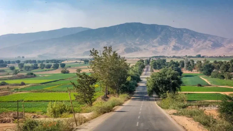
Geographical Landscape and Climate
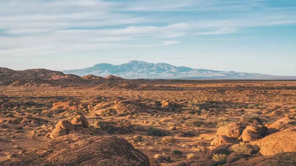
Panjgur is positioned between 26°-14′ and 27°-18′ north, and 63°-07′ and 65°-24′ east. It covers 16,891 square kilometers, characterized by mountainous terrain stretching from north-east to south-west. The Siahan range dominates the central Makran region, with varying elevations.
The climate of Panjgur is cold and arid, with desertification potential. Summers start in May, lasting until October, while winters bring cold winds known as Goorich. The highest recorded temperatures range between 37.0°C and 39.5°C, while in January, the minimum can drop below freezing.
Agriculture and Natural Resources
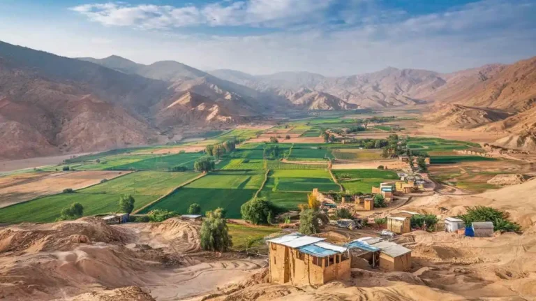
The District Resources of Panjgur indicate that 60.1% of the land is reported, with only 5% under cultivation. Irrigation plays a crucial role, yet a significant 35.2% of the land remains waste. As per Agricultural Statistics (Balochistan, 1994-95), 1,689,091 hectares are accounted for, with 1,015,863 hectares used and 673,228 hectares remaining unutilized.
The soils in Panjgur are mostly alluvial, with desert loam near Kharan and rocky regions in the foothills. The fertile lands along the Rakhshan River, Parome, and Isai valley support date trees, wheat, and other crops. However, torrential streams often bring challenges like erosion.
Minerals such as antimony, sulphur, and salt have been reported, with significant reserves found in Padkash (3512.4 tonnes) and Korkian. Mining remains under private leaseholders, but full exploration is yet to be realized.
Environmental Concerns and Energy Supply
The environment in Panjgur faces threats like wind erosion, solid waste disposal, and grey pollution. Areas like Chitkan and Rakhshan River suffer from civic negligence. Public health planners emphasize the need for proper drainage and waste management.
Energy resources remain a concern. Electricity supply is erratic, leading to reliance on Iranian petrol, diesel, and LPG. The cost of petrol fluctuates between 6 to 12 rupees per liter, impacting trade, transportation, and tubewells. Shopkeepers in Chitkan frequently rely on kerosene oil and fuel wood for illumination and cooking.
Historical Landmarks and Shrines
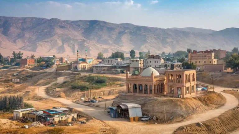
Panjgur is home to ancient ruins like Kuhna Kalat, built using red bricks, possibly by Persians. Malik Asa introduced glazed bricks, shaping decorative architecture. The Band-e-Gillar, an ancient dam, supported men and animals, showcasing old irrigation techniques.
Religious sites include the shrines of Shah Qalandar and Pir Umar, adorned with baked tiles and engraved inscriptions. These aoliya (saints) played a role in shaping Islamic traditions. The name Panjgur itself derives from “panch gor”, meaning five graves, linked to the legend of five lights (Panchnur) and a stream (kor) that sustained early settlements.
Economic and Social Dynamics
Panjgur’s economy relies on agriculture, trade, and livestock. During the 1960 flood, large date trees and crops were damaged, affecting revenue. In 1960, a cholera outbreak in Bonistan and Isai highlighted the lack of clean drinking water.
The demography and housing statistics from 1951 to 1981 show population growth trends, with dependency ratios fluctuating. Rural-to-urban migration has influenced employment, leading to Gulf migration for work. The household size remains large due to joint family norms.
Housing in Punjgoor
Housing Structure and Census Data
Punjgoor’s housing system has evolved over time, reflecting cultural traditions and economic conditions. According to the 1980 housing census, the district had 18,845 houses. The average crowding rate was 8.0 persons per house. Many families lived in one-room houses, comprising 7.1% of total dwellings, while 84.6% of homes had more than one room. Only 15.4% of houses were built with a boundary wall for privacy and security.
House Ownership and Tenure
In 1980, about 99% of houses were occupied by their owners, while very few were rented or rent-free. The concept of renting was more common in the urban area, whereas in rural areas, tradition dictated that people built their own homes. Some government offices and buildings were also used to house immigrant labour working in the region.
Construction Materials Used in Buildings
The construction material used in Punjgoor reflects local resources and affordability. Most buildings were built using mud, un-baked bricks, and courtyard walls made from local elements. Roofs were constructed using trunks and leaves of date trees, often supported by pish mats. Some modern houses incorporated concrete blocks, cement, gravel crush, and sand for durability. RCC, iron girders, kiln bricks, tiles, and chimneys were introduced for improved strength. A few plastered houses were better protected against rains.
Energy Sources for Lighting and Cooking
Before electrification, kerosene oil lamps were a major source of light in Punjgoor, especially in Chitkan and surrounding villages. By February 1997, the town had 2,192 supply connections, including 1,760 domestic connections. However, electricity was available for only 11 hours a day, limiting the use of electric appliances. In villages, generators were used as alternatives. Cooking relied heavily on fuel wood, kerosene oil stoves, and other petroleum products, with some supply coming from cross-border trade. The use of Liquefied Petroleum Gas (LPG) was also growing, with cylinders of 3,000 and 11 kg being used by both males and females.
Housing Characteristics
The 1980 census revealed that 84.6% of houses had at least one room, often serving multipurpose functions. 38% of houses had a separate kitchen, while 42% had separate bathrooms and 95% had separate latrines, though only a few had flush systems. Some homes were without a kitchen (16%), without a bathroom (11%), and without a latrine (3%), indicating inadequate sanitation facilities.
Drinking Water and Sanitation
Water supply was a significant challenge in Punjgoor. In 1981, only 0.7% of homes had piped drinking water, while 71% relied on open surface wells and 28% used springs and karezes. Proper latrines and flush systems were rare, and sanitation services were limited. The Public Health Engineering Department (PHED) initiated 33 water supply schemes by December 1996, of which only 22 were functional. These projects included pipelines and community tanks for water storage.
The Local Government and Rural Development Department (LG&RDD), with support from UNICEF, installed 190 deep well hand pumps and built 200 latrines in public places and government offices. However, the overall sewerage system remained inadequate, with drainage issues affecting streets. The Town Committee Chitkan managed waste disposal using a tractor trolley, but garbage collection services were not efficient.
Major Development Issues
Punjgoor has faced several challenges linked to population growth rate (3.0%), with a density of 14.4 persons per square kilometre. The Baloch community has an average household size of 8, and the fertility rate is 11.4. The mean age of marriage for females is 21.7, affecting family planning efforts.
Census data often struggles with under-enumeration, particularly of girls aged 5 to 25 years, leading to cultural deprivation. Addressing these challenges requires targeted policies and strategies, especially in rural areas where access to civic facilities, drinking water, waste disposal, link roads, and electric supply remains limited.
Economic activity in Punjgoor revolves around agriculture, livestock farming, government service, and work by allied workers. Handicrafts also provide income, but further development is needed to improve living standards.
Federal and Provincial Government Administration in Panjgoor
Panjgoor’s administration operates under both federal and provincial structures, ensuring smooth governance and policy implementation. The Deputy Commissioner (DC) acts as the head of the district, overseeing law enforcement, planning, and development. Various departments, such as Ushar, levies, and tax, function under the supervision of the Commissioner, who liaises with committees and forums to address public issues.
At the provincial level, Naib-Tehsildars, Tehsildars, and Assistant Commissioners play an intermediary role in administrative affairs. They handle transfers, law, and order maintenance, ensuring that government policies align with socio-economic needs. This macro and micro governance approach ensures that both long-term and short-term planning needs are met. Despite structured policies, adhocism remains a challenge, causing delays in execution and limiting the effectiveness of government programs.
Law and Order Maintenance in Panjgoor
Security in Panjgoor is managed through police, Levies, and Rangers, with their headquarters in Chitkan. The DC, along with officials, ensures law enforcement against smugglers, culprits, and theft activities. Police stations and border posts near Iran monitor cross-border movements to curb illegal trade. DSP and other officers remain vigilant against crimes like robbery, snatching, and motorcycle theft.
The Makran region, including Panjgoor, has seen a relatively increasing crime rate, though it is controlled through vigilance and strategic decision-making. Special platoons are stationed at key areas to enhance supervision. In 1963, law enforcement was reinforced, and by 1969, additional divisions were formed for better crime control. However, there is a need for better enforcement to ensure sustainable security.
Revenue Administration in Panjgoor
The district administration is responsible for revenue collection, ensuring financial stability through tax, levy, and customs duties. Funds are allocated for infrastructure, business growth, and public services.
In Chitkan, the primary revenue center, charges on vehicles, water, and livestock are collected. Despite attempts at privatisation, unsuccessful efforts have led to lesser economic development. Contractors and business entities engage in bidding processes, but competition remains weak due to obstacles in local administration. The Pakistan government has launched initiatives to address these liabilities, yet cooperation between agencies and local council is required for better economic growth.
Political Parties in Panjgoor
Panjgoor’s political landscape is shaped by various parties, including BNP, BNM, JUI, PML, and PPP. These political groups influence local elections, with many representatives focusing on nationalist and rightist ideologies.
In 1997, multiple seats were contested by workers, student wings, and unions. Prominent leaders like Bizinjo, Mengal, and Lehri played major roles in shaping governance. The provincial assembly remains a key forum for policy debates, though opposition groups continue to challenge vested interests. Recently, student participation in politics has surged, indicating a shift towards regional governance.
Non-Government Organisations in Panjgoor
Several NGOs are registered in Panjgoor, focusing on education, development, and welfare. However, many remain unregistered due to bureaucratic hurdles. Organizations like Helper Pak, RCDC, and PEDP work towards primary education, especially for girl’s schools in rural areas.
These organisations conduct projects that promote communication, collaboration, and community welfare. Some focus on youth and football clubs, motivating males and females towards skill development. Despite these efforts, challenges persist in association registrations and funding limitations.
Forestry in Panjgoor
Panjgoor’s forest landscape consists of tamarix, prosopis, and barshonk trees. The Divisional Forest Officer (DFO) oversees plantation efforts to prevent illegal cutting of fuel wood. In the Rakhshan district, scarce vegetation like kandaar, kahur, and guldar is protected for pharmaceutical use.
The area also has clusters of spiny plants like morpuzo, danichk, and ispaghol, which serve as fodder for livestock. Forestry plans aim to restore disappeared species, ensuring sustainable resource management.
Wildlife in Panjgoor
Panjgoor is home to diverse wildlife, including red wolves, caracal, gazella, and ibex. The Canis pallipes species is commonly found in mountainous habitats. However, illegal hunting of bustards, deer, and foxes has threatened biodiversity.
Efforts for conservation have led to the protection of endangered species like Sind gazella. Occasionally, wild boars and hares are spotted near ravines and cultivation areas. To maintain ecological balance, strict security measures are enforced under international wildlife protection laws.
Bee-Keeping in Panjgoor
Beekeeping is an emerging economic activity in Panjgoor. Traditionally, honey was collected from wild hives, but modern apiculture techniques are being introduced. Local people have begun training in sustainable harvesting, ensuring better quality honey production.
With untapped resources, structured keeping and gathering practices can enhance local markets. Establishing apiary networks and hives will provide better economic opportunities and promote the occupation of professional beekeepers.
Small Enterprise Development in Panjgoor
Despite infrastructure challenges, small enterprises are gradually developing in Panjgoor. Federal and provincial initiatives support training programs for vocational skills. However, financial constraints hinder establishment efforts.
Both men and women seek opportunity in workshops, but the attitude towards entrepreneurship remains conservative. To bridge these gaps, planning and resource provision need enhancement.
Manufacturing in Panjgur
Panjgoor has potential for manufacturing, including furniture, embroidery, and soft drinks. Small factories are being established, but challenges like electricity shortages and labour constraints limit growth.
The demand for processed and local products in Quetta and Karachi remains high. Encouraging female participation and better availability of raw materials can boost the sector.
Trade in Panjgur
Illegal trade of imported goods like LPG, sugar, and flour from Iran affects the local market. Customs officers and officials regulate cross-border transportation, ensuring fair permits and pricing.
Due to shortage of goods, traders rely on smugglers to meet consumer demand. Establishing legal trade networks can create better economic stability.
Tourism in Panjgoor
Despite historical sites like Khan fort, tombs, and Khudabadan, tourism remains underdeveloped. Poor infrastructure and expensive accommodation prevent visitor growth.
Investing in routes, hotels, and transportation can attract more tourists, promoting economic growth while preserving heritage.
Handicrafts in Panjgur
Panjgoor is known for handmade Balochi embroidery, mats, and baskets. Women play a key role in producing.
The Rich History of Panjgur
Panjgur, located in Balochistan, is one of the most historic regions in Pakistan, with a legacy that stretches back thousands of years. This land, once part of British India, has seen many rulers, migrations, and battles, shaping it into the culturally diverse district it is today. From ancient Princely States to the impact of the One Unit Policy, Panjgur’s history is a fascinating tale of resilience and evolution. The region has not only been a witness to historical events but has also played a role in shaping them, contributing significantly to the sociopolitical and economic dynamics of Balochistan.
Ancient Legends and the Influence of Folklore
According to oral history and folklore, Panjgur’s early existence is linked to the time of Prophet Dawood. It is believed that a devastating famine struck the land, leading to the establishment of settlements near water sources such as dambi (natural springs). Legends also mention the influence of Iranian King Kaus and the famous warrior Afrasiab of Turan, whose conflicts and battles are part of the region’s mythical past. Additionally, Panjgur is said to have been a part of the ancient trade routes that connected the Persian Empire with the Indian subcontinent, facilitating the exchange of goods, culture, and ideas.
Persian and Greek Influence
The Persian kings, including Kai Khusrau, Lehrasp, Gushtasp, Bahman, Huma, and Darab, had their influence on the area. In 325 BC, Alexander the Great marched through Gadrosia (modern-day Makran) on his way back to Macedonia. His army, led by Kanazbun, faced extreme hardships in the arid terrain. Greek historians like Arrian recorded the difficulties that Alexander’s forces endured. Later, the region came under the rule of Seleucus Nicator, who eventually ceded it to Chandragupta Maurya in 303 BC. This transition marked the beginning of an Indo-Greek influence that introduced new agricultural practices, governance models, and trade systems in the region.
The Islamic Era and Arab Influence
With the spread of Islam, Panjgur became a significant region in Sindh and Hind. During the time of Shermah, Malik of Hind, the Arabs arrived, bringing profound cultural and religious changes. The Islamic conquest began in 643 AD when Khalifa Umar bin Khattab sent Abdullah Ibn Uthban to Balochistan. By 711 AD, Muhammad bin Qasim had firmly established Islamic rule, influencing local traditions, governance, and trade. The introduction of Islamic jurisprudence, architecture, and educational institutions led to a major transformation in the socio-political fabric of Panjgur. The local population gradually adapted to Islamic customs, and many Arabic words became integrated into the Balochi language.
Medieval Dynasties and Conflicts
Panjgur witnessed the rule of the Seljuks, Ghaznavids, Ghorids, Mongols, and Portuguese invaders. These various rulers left their imprint on the region, whether through architecture, governance, or trade. The Hoths, Rinds, Maliks, Buledais, and Gichkis played crucial roles in the local administration and military. The rise of the Zikri sect in Makran also shaped Panjgur’s religious and social landscape. The Mongol invasions brought destruction but also led to the migration of scholars, traders, and artisans who enriched the region’s cultural diversity.
Colonial Rule and Resistance
During the colonial era, Panjgur came under British influence. Maskat and Buleda saw political struggles, particularly during the reign of Mir Nasir Khan I (1749-94). His expeditions against the Zikris reshaped the power structure. Later, Mir Mehrab Khan and Faqir Muhammad Bizenjo continued to resist foreign dominance. The First Afghan War (1838-39) further complicated regional politics. The resistance movements against British rule were fueled by tribal alliances and a deep-rooted desire to maintain autonomy. Panjgur remained a crucial node in the larger struggle for independence in Balochistan.
British Administration and Strategic Importance
In 1861, Major Goldsmith was appointed as an Assistant Political Agent in Gwadar, overseeing Panjgur. By 1863, local leadership was under Mir Gajian, who ruled as Sardar. The Makran Levy Corps, established during the colonial era, played a vital role in maintaining security. By 1903, the Khan of Kalat had consolidated power, making Panjgur a strategic area. The British considered Panjgur an important military and trade route due to its geographical positioning. The construction of military garrisons and telegraph lines further integrated the region into the colonial administration.
Post-Partition Developments
After the Partition of 1947, Panjgur became part of the newly formed Pakistan. Initially, it was integrated into the Balochistan States Union (1949), alongside Kalat, Lasbela, and Kharan. However, in 1955, under the One Unit Policy, it became part of West Pakistan Province. By 1970, it was officially recognized as part of Balochistan Province. Later, in 1977, Panjgur was designated as a district, with Turbat and Kech forming adjacent administrative divisions. These changes brought administrative restructuring and attempts to integrate the region into the national economy through developmental projects.
The Name and Geography of Panjgur
The etymology of Panjgur stems from “panch” (five) and “gor” (graves), referencing the five saints believed to be buried there. Historically, it was also called Panchnur and Panchkor, representing the region’s abundant streams and water bodies. The Rakhshan River has played a crucial role in the evolution of the region’s agricultural and economic systems. The fertile lands near the river have supported date palm cultivation, a major economic activity for the local population.
Political and Administrative Structure
At the federal level, Panjgur is represented in the National Assembly and the Provincial Assembly. It has allocated seats under the Local Government Act (2010) and its Amendment (2011). The District Council oversees governance, with 21 Union Councils and Municipal Committees in Chitkan and Tasp. The region ensures 33% representation for women and 5% for workers and peasants in local governance. Panjgur’s governance system is designed to accommodate traditional tribal leadership alongside modern administrative structures.
Administrative Divisions and Infrastructure
Covering 16,891 km², Panjgur consists of multiple tehsils and Union Councils. The Panjgur Tehsil alone has 11 Union Councils, while Gowargo Tehsil comprises 5 Union Councils. Despite its vast expanse, development remains a challenge, especially in remote areas. Infrastructure development, including roads, healthcare facilities, and educational institutions, has been slow but steady over the years.
Tourism and Heritage Sites
The Government of Pakistan has recognized various Protected Heritage Buildings in Panjgur. Notable among them is the historic Fort of Nawab Habibullah Khan in Kharan. The Khudabadan Fort, which once housed the last ruler in 1952, remains an architectural marvel. Azad Khan, a prominent forefather, constructed multiple forts across the region, reinforcing its strategic importance. Additionally, the ancient mosques and shrines in Panjgur reflect its long-standing religious and cultural heritage.
The Formation of Panjgur as a District
Located in the west of Balochistan, Panjgur was once part of the Makran District before being officially designated as a district on July 1, 1977, within the Makran Division. Several towns, including Tasp, Kallag, Paroom, Washbood, Gramkan, Sarawan, Khudabadan, and Chitkan, form the district’s key settlements.
Modern Administration and Education
The district comprises three tehsils and 16 Union Councils, including Paroom, Panjgur, and Gichk. Education in Panjgur has improved over time, with multiple high schools, private institutions, and a Cadet College offering quality education.
Panjgur remains a region of historical, political, and cultural significance. Its evolution from ancient settlements to a modern district reflects a rich tapestry of resilience, tradition, and growth.
Conclusion and Future Prospects
Panjgur’s potential for development lies in agriculture, trade, and resource exploration. The arid climate, limited irrigation, and employment opportunities need urgent attention. Investments in fertilizers, seeds, pesticides, and afforestation can enhance agricultural output. Addressing environmental pollution, cross-border trade regulations, and energy shortages will shape Panjgur’s future. The district holds promise, but sustainable development remains key to progress.