Killa Saifullah: A Land of History and Nature
Killa Saifullah
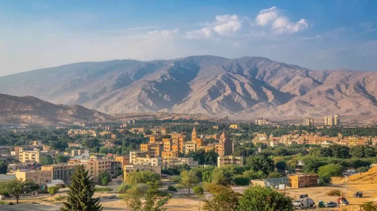
A Glimpse into Killa Saifullah
Nestled in northwestern Balochistan, Pakistan, Killa Saifullah holds a unique place in the region’s history and geography. The name translates to the Fort of Saifullah Khan, signifying its historical importance. The district was officially established in 1988, after being separated from Zhob District. Earlier, it was part of the Upper Zhob Sub-division and later gained recognition as an independent district. The district includes administrative units such as sub-tehsil, Badinai, and Kashatoo.
Judicially, the region has structured courts under the Sessions Division, with an Additional District and Sessions Judge, a Civil Judge, and a Judicial Magistrate handling legal matters. The region also has a traditional influence, with the Majlis-e-Shoora and Qazi playing roles in legal proceedings. The judicial system ensures proper law enforcement with the support of the Sessions Judge and Additional Sessions Judge. The district also comprises significant towns like Muslim Bagh and Loiband, which contribute to its economic and cultural landscape.
Geographical Features of Killa Saifullah
Located in the northeast of Balochistan, Killa Saifullah shares borders with Pishin district, Zhob district, Loralai district, and Afghanistan. Geographically, it lies between 30° 31Ꞌ and 31° 22Ꞌ north latitudes, and 67° 29Ꞌ 37” to 69° 20Ꞌ east longitudes. This location places it at a strategic crossroads between major trade and cultural routes, contributing to its historical significance.
Demographics and Economy of Killa Saifullah
With a Population of 342,814 persons, spread over an Area of 6,831 km², the district has a Population Density of 27.6 persons/km² and a Growth Rate of 3.1%. The Male Population constitutes 53.1%, while the Female Population is 46.9%. The Urban Population accounts for 18.3%, with the rest residing in rural areas.
Administratively, the district is divided into 03 Tehsils:
- Killa Saifullah Tehsil
- Muslim Bagh Tehsil
- Loi Band Tehsil
Several Main Towns such as Akhtarzai, Khan Mehtarzai, Sadar Batozai, and Murgha Faqirzai add to the district’s socio-economic fabric. The Literacy Rate stands at 40%, with a major disparity between Male Literacy (76%) and Female Literacy (6%).
Economic Activities and Agriculture
The district’s economy revolves around Agriculture, livestock breeding, fishing, and hunting, engaging 46.8% of the workforce. Other sectors include:
- Construction: 21.1%
- Community, Social, and Personal Services: 19.8%
- Electricity, Gas, and Water Supply: 5.4%
- Wholesale, Retail, Hotel, and Restaurant Businesses: 3.3%
- Manufacturing: 2.7%
- Others: 0.9%
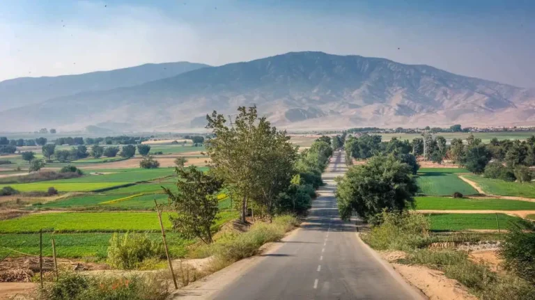
The district produces various Main Crops, including wheat, barley, cumin, tobacco, maize, moong, maash, sunflower, cotton, and fodder. Additionally, it is known for its Major Fruits, such as almonds, apples, apricots, grapes, peaches, pomegranates, cherries, watermelon, musk melon, sarda, garma, and plums. It also cultivates Major Vegetables like onions, potatoes, tomatoes, okra, carrots, bottle gourd, pumpkin, cauliflower, peas, brinjal, luffa, cucumber, chilies, spinach, and tinda.
Infrastructure and Connectivity
The district boasts 28,051 HA of Forests and a well-developed road network, including 802.0 km of Black Topped Roads and 947.0 km of Shingle Roads. The Quetta Electric Supply Company (QESCO) provides Electricity, while the communication network includes 02 Telephone Exchanges, 848 landlines, 365 wireless phones, and 637 broadband connections. Despite these advancements, the district lacks Industrial Zones but has small-scale furniture-making industries in Muslim Bagh.
The Household Size in the district averages 7.1 persons per house, but basic utilities remain a challenge, with only 13.5% of Houses having Piped Water and 41.2% having Electricity.
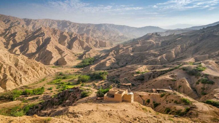
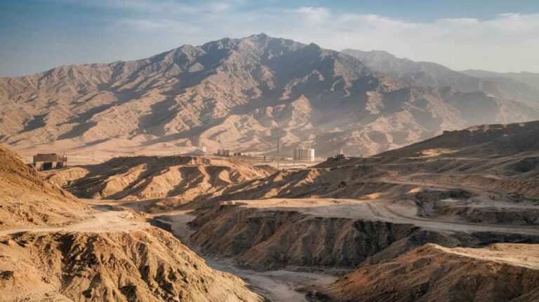
Landscape and Natural Beauty
The district’s Mountainous terrain includes valleys, hills, and rocks, forming part of the Zhob Valley and Quetta Valley. Several prominent peaks and landmarks define the region:
- Kan Mehterzai Pass (Elevation: 2,170 m)
- Toba Kakar Range
- Torghar
- Shagana Kotal (2,070 m)
- Azak (2,557 m)
- Baliaraghar (2,958 m)
- Spin Ghar
- Ghina-ghara (2,646 m)
- Shorghar
- Yavhashki (2,964 m)
- Muslim Bagh Sub Division
- Kand (3,288 m)
- Surghund (3,234 m)
- Atoka (3,007 m)
The Central Asian watershed influences the hydrology of the district, contributing to its diverse ecosystem. The Indus River and its tributaries provide water to the valleys, sustaining the local economy.
Water Bodies and Streams
Several Rivers, Streams, and Lakes flow through the district, including Lahar, Kundar, Wali, Murgha Toi, Kumchugai, Rod Faqirzai, and Marzaghan. Seasonal hill torrents such as Toi and Kamchughai bring floods during the rainy season, replenishing water sources like Bahrwala Viala, Ziara Lahar Viala, and Zharai Viala.
Flora and Fauna
The district features diverse Forests, including coniferous and scrub forests found in Torghar. The dominant trees include chilghoza, kail, wild olive, ash, willow, and shina. Other native species like Pistacia khinjjuk, Fraxinus xanthoxyloides, obusht, Juniperus excelsa polycarpos, and ghaz add to the biodiversity. According to Balochistan Development Statistics 2018-19, about 180,000 HA of land falls under the Torghar Conservancy.
Soil and Climate
The soil types vary from loamy and gravelly to valley-fill and rock outcrops, as recorded in the Atlas of Pakistan. The region experiences an arid to semi-arid climate, with elevation ranging from 1,500 to 2,200 m. Summers are warm, with temperatures averaging 21°C to 32°C, and peak at 38°C in June. Winters are cool, with January bringing frost and temperatures as low as 10°C. The Kan Mehterzai Pass (2,170 m) remains snow-clad during freezing cold spells, often experiencing katabatic winds. The district receives an annual rainfall of 260 mm, as recorded by GoB, UNICEF, and P&D Department.
Seismic Activity
Located in Seismic Zone 4, Killa Saifullah is prone to earthquakes that can cause severe damage. Proper measures are needed to mitigate risks in this active zone of Pakistan.
Economic Activity in Kila Saifullah District
Kila Saifullah District has a diverse economic activity that supports the local population. Agriculture and livestock breeding are the main sources of income. The wholesale and retail sectors also play a significant role, accounting for 21.1% of the district’s economy. The manufacturing industry contributes 5.4%, while construction accounts for 2.7%. Additionally, electricity, gas, and water services contribute 19.8% to the district’s financial structure. A large part of the workforce is engaged in personal services, hotel, and restaurant businesses, making up 46.8% of employment. Despite the potential for fishing and hunting, these industries remain underdeveloped in the region.
Land Use in Kila Saifullah District
Covering an area of 683,100 HA, Kila Saifullah District has a mix of cultivated and uncultivated land. The total cultivated land is 262,981 HA, while 101,384 HA is net sown. The current fallow land is 20,287 HA, and the uncultivated land reaches 416,780 HA. The forest area spans 81,994 HA, while reported waste land covers 71,805 HA. Data from Balochistan Development statistics 2018-19 shows that land distribution is a crucial aspect of regional planning.
Agriculture in Kila Saifullah District
Agriculture is a major contributor to Kila Saifullah’s economy, with both crops and fruits being cultivated extensively. The district is known for tobacco, cumin, wheat, barley, and cotton. Vegetables such as okra, pumpkin, spinach, brinjal, cucumber, and peas are widely grown. The region is also famous for fruits, including grapes, apricots, cherries, almonds, pomegranates, peaches, and watermelons. Additionally, bottle gourd, sunflower, moong, and musk melon are harvested seasonally, while chilies and tomatoes are commercially exported.
Livestock Breeding in Kila Saifullah District
The district is home to various breeds of livestock, including cattle, sheep, goats, camels, and donkeys. The koh-i-Suleimani and raigi breeds are common among local herders. The total number of heads recorded includes 270,151 cattle, 69,361 sheep, and 1,066,690 goats. Indigenous breeds such as dumeri, sperki, gosalli, shinghari, and khurasani are reared for income and trade. Nomadic herders move between pastures, making livestock breeding an integral part of the district’s economy.
Poultry Farms in Kila Saifullah District
The poultry industry in Kila Saifullah is growing, with both commercial and household farms contributing to local food production. The total number of poultry farms has increased, but official data available is limited. These farms produce meat and eggs, fulfilling local demand.
Fishing in Kila Saifullah
Fishing is not a major activity in the district due to the no presence of significant water bodies.
Bee Keeping/Apiary in Kila Saifullah District
The region’s arid climate and scanty rainfall make bee keeping a negligible industry. The nature of the local vegetation does not support large-scale beekeeping.
Irrigation Network in Kila Saifullah District
The irrigation system in the district relies on various sources, including karez, wells, canals, and springs. There are 87,080 HA of private wells, 64 canals, and 87,144 HA of tube wells. The Balochistan Development statistics highlight government initiatives such as delay action dams in Malgagi, Murgha Faqirzai, and Akhtarzai. The Soghai, Tor Kane, and Mustafa networks help in recharging water supplies.
Manufacturing/ Industry in Kila Saifullah District
The manufacturing sector includes small and medium units, with only a few large organized industries. Furniture making is a key trade, and local artisans contribute to the industry through traditional craft making.
Mining in Kila Saifullah District
The district is rich in natural resources, including coal, limestone, marble, chromite, copper, iron ore, and magnesite. Muslim Bagh is a well-known area for mining, with soapstone and asbestos deposits also present.
Handicrafts in Kila Saifullah District
The region has a thriving cottage industry, with women engaged in embroidery, dress making, and handicraft production. These personal skills are well-developed in villages and towns, with items being sold locally and on order.
Economic Infrastructure in Kila Saifullah District
The district has a network of roads, highways, and junctions that connect it to major parts of the province. The N-70 highway links Kila Saifullah with Pishin, Loralai, and Dera Ismail Khan. The Balochistan Development statistics 2018-19 report 802.0 km of total roads, including shingle and high-grade roadways.
Rail and Airways in Kila Saifullah District
The Kan Mehtarzai railway station, once the highest in Asia, was closed in 1986. The nearest airport is in Quetta and Zhob.
Radio and Television in Kila Saifullah District
Due to the absence of local TV transmission stations, people rely on satellite dishes and cable services. BBC, Karachi, and Lahore transmissions are widely received.
Telecommunications in Kila Saifullah District
The Pakistan Telecommunication Corporation (PTC) operates 2 telephone exchanges, with 848 landlines and 637 broadband connections.
Post Offices/ Courier Services in Kila Saifullah District
The district has 02 post offices and several courier services.
Banking/ Financial Institutions in Kila Saifullah District
There are 12 conventional banks and 5 Islamic banks, including National Bank of Pakistan and Muslim Commercial Bank.
Electricity and Gas in Kila Saifullah District
The Quetta Electric Supply Company (QESCO) provides electricity, while gas is supplied through LPG cylinders.
Educational Institutions in Kila Saifullah District
The district has 414 primary schools, 214 middle schools, 30 secondary schools, and 6 higher secondary schools.
Healthcare Facilities in Kila Saifullah District
There are 2 teaching hospitals, 70 rural health centers, and 15 dispensaries in the region.
Policing in Kila Saifullah District
Law enforcement is managed by regular police, levies, and the Deputy Commissioner (DC). The Federal Bureau of Statistics 2019 reports 2 police stations.
Environment and Biodiversity in Kila Saifullah District
The state-protected Torghar Conservancy is an important wildlife sanctuary for the Suleiman markhor and Afghan urial.
Killa Saifullah: A Unique District in Balochistan
A Glimpse into Killa Saifullah
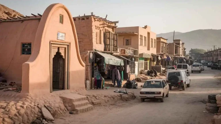
Located in the north-east of Balochistan, Killa Saifullah is a historic region with deep cultural roots. The name of this district headquarters originates from Saifullah Khan, a leader from the Khoidadzai tribe known for his chivalry and nobility. Historically, it was part of Zhob and was declared a separate district in December 1988. The region is bordered by Afghanistan, Sindh Province, and other districts like Awaran, Gwadar, and Khuzdar. The town serves as an administrative and trade hub.
A Deeply Rooted Tribal Society
The society in Killa Saifullah is shaped by tribal values and strong kinship bonds. The nawabs and sardars hold considerable influence, with the Jogizais enjoying a superior status due to their economic affluence. The district is considered a cradle of Afghans, where the normative structure is deeply tied to Pushtun culture. With educational expansion and media exposure, traditional traditions persist, including customs like vulvar (bride price), hospitality, and the presence of fire arms. Rivalries among tribes are still prevalent, often influencing local decision-making.

Family and Marriage Traditions
Marriage is a major milestone in a young-man’s life. Once he reaches puberty, his family begins searching for a match. The fathers of both the bride and groom engage in mutual discussion about the family background, physical attraction, and total bride-price (which includes vulvar money and dowry). The final proposal acceptance is followed by dua-e-khair and a formal engagement. The wedding involves significant expenses, including entertainment, a valima feast, and numerous guests from the clan, including celebrities. The system of bride-exchange and endogamy is common, reducing rivalry and ensuring familial bonds.
However, elopement is a taboo, and those involved may be murdered due to family-member honor. Adultery is met with severe punishment. Most marriages follow a patrilocal system, where the bride moves into the groom’s household. The structure of joint and extended families is widely accepted, though nuclear families are emerging due to socio-cultural norms and economic compromises. The duty of caring for old-aged parents is a shared responsibility.
Structure of Society
The society of Killa Saifullah is shaped by kinship, tribal identity, and clan affiliations, with last names denoting status. The sardars hold political and social power, often through hereditary succession. The Jogizais maintain a higher status, with their households being centers of mediation and communal leadership.
Older, educated individuals are respected as community leaders, influencing collective welfare and development. Wealth, social prestige, and family background determine a person’s role in society. Syeds often act as mediators in political decisions and provide support in case of conflict. Nawabs, sardars, and Syeds traditionally resolve disputes on a communal basis rather than in a court.
Religiously, the census indicates that the majority of the population are Muslims, with a minimal presence of Christians, Ahmadis, Hindus, Parsis, Sikhs, and Buddhists. The dominant sect is Sunni, following the Hanfi school of thought, adhering to Shariah laws. Islamic principles dictate inheritance and property rights. Islamic festive days are celebrated with great zeal and fervour.
Customs of Co-operation
The characteristic feature of gemeinschaft (close-knit rural life) is visible in Killa Saifullah’s agricultural society. People form intense relationships and co-operate in tasks like sowing, reaping, and thrashing. Formal co-operation is facilitated by organizations like the Balochistan Rural Support Organisation, Apple Production and Marketing Association, and various Village Organisations.
These organizations are active in development, focusing on agriculture, horticulture, livestock, and infrastructure. Community participation fosters self-reliance. The Women Organisation plays a vital role in socio-economic development, particularly in water supply schemes, Public Health Engineering Department, and Water Management Associations, ensuring tariffs, consumers, and minor repairs remain sustainable.
Role, Position, and Status of Women
Women in Killa Saifullah often remain secluded within the boundary of their household. Their freedom in routine decisions, inheritance, and access to Islamic rights is limited. While some women participate in the formal sector, taking government jobs as education and health workers, many are involved in income-generating activities related to agriculture and livestock, though their labor remains unaccounted.
According to MICS 2010, the female literacy rate among those aged 15-24 years was 15.4%. Programs like the Balochistan Rural Support Programme and Women Organisation have increased participation and awareness, providing a viable platform for economic independence and social independence.
Despite this, male domination persists. Women graze livestock, fetch water, and collect fuel wood but have limited say in domestic decisions and major issues like marriages. Their advisory role is often restricted. Unmarried girls rarely visit bazaars, and a medical check-up without a male family member is still an appreciable act.
The preference for sons over daughters is evident in education, health, and nutrition. Resources spent on girls are often seen as a waste, leading to financial dependency. Access to an exclusive health facility for mother-child health care remains a challenge. Higher education is limited, with only a boys’ college available in the entire district. Political participation is also restricted, with women needing a male family member’s approval to vote or contest elections in the District Council, Union Councils, and UC Tubli.
Killa Saifullah: A Land of Rich History and Heritage
Origins and Historical Background
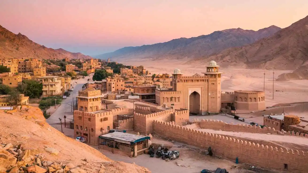
The history of Killa Saifullah is deeply rooted in the tribal traditions and historical shifts of Balochistan. The region has been home to different rulers and civilizations, leaving behind a legacy of forts, mounds, and karezes. The name Killa Saifullah translates to “Saifullah Fort,” named after Saifullah Khan, a notable leader of the Mirdadzai clan of the Khoidadzai tribe of Kakars.
According to the Zhob District Gazetteer (1907), the region was historically significant due to its strategic location and strong tribal presence. Various tribal agencies controlled the area before it came under British rule. It became an administrative district in 1988.
Ancient and Medieval Influence
The earliest mention of the region appears in accounts of the Chinese pilgrim Hiuen-Tsang, who traveled through this area in the 7th century AD. Later, during the 13th century, Genghis Khan and his Mongol forces passed through this region. In 1398 AD, Pir Muhammad, the grandson of Amir Timur, played a significant role in the Timurid expansion into the area.
The Mughals left a lasting impact, constructing forts and establishing trade routes. Various archeological sites such as Mughalo Killa and Karezgai village have yielded silver coins and copper coins, confirming Mughal presence.
Durranis, Barakzais, and the British Era
Following the downfall of the Mughals, Nadir Shah (1736-47 AD) and later Ahmed Shah Abdali (1747-73 AD), also known as Ahmed Shah Durrani, established control over the region. The Durranis and Barakzais ruled until the British took over.
During British rule, local chiefs were granted sanads (royal grants) to maintain their loyalty. The Jogezai family, led by Bekar Nika, played a crucial role in resisting British influence. Shah Jehan Jogezai, known as the King of Zhob, and Shahbaz Khan were among the key tribal leaders of the time.
During the First Anglo-Afghan War (1878), British forces moved into Zhob, facing resistance from local Sardars such as Dost Muhammad and Bangul Khan. The British officially took control of Killa Saifullah on 7 October 1884, after securing Killi Rabat Karez. Later, it became part of the Political Agency in 1890, with Captain McIver as the Political Agent in Pishin.
The Durand Treaty (1893) further solidified British control, defining borders between British India and Afghanistan. By 1924, the district was fully integrated into British administration.
Significant Historical and Archeological Sites
Numerous historical sites, heritage sites, and archeological sites are scattered across Killa Saifullah. The region is home to remnants from the Mughal period, including:
Mughalo Killa
Karezgai village (3.75 km from the main town)
Khanki Fort
Shina Khura (25 km away)
Miro, a Mughal governor’s stronghold
Murgha Faqirzai, Toiwar, and Sharan
Zhar Hill and Ismailzai
These sites contain ancient pottery, silver coins, gold coins, and spring of water sources, showing their historical significance.
Geopolitical and Cultural Transitions
The Jogezai family and other tribal leaders played a key role in shaping Killa Saifullah’s governance. The region was officially declared a district on 14 December 1988, becoming an essential part of Upper Zhob Subdivision.
Additionally, the Kakar Khurasan area, along with Badinai and Kashatoo, became significant parts of the district’s expansion, eventually leading to the establishment of Loiband sub-Tehsil in 2002.
Killa Saifullah’s Link to Railway and Transport
One of the most remarkable features of Killa Saifullah is Kan Mehterzai, known as Asia’s highest railway station. Located at 3,339 meters above mean sea level, it played a crucial role in British transportation networks, particularly for military movements during World War I and World War II.
The region’s Tehsils, such as Muslim Bagh (formerly Hindu Bagh) and Killa Saifullah Tehsil, have continued to develop, maintaining their historical identity while integrating modern infrastructure. By 1903, these areas were already recognized administrative units, highlighting their longstanding significance.
Uncovering the Legacy of Ancient Karezes
The region has an extensive system of ancient karezes, underground water channels that date back to early civilizations. Key karezes include:
Karez Akhtarzai
Karez Soghai
Mustafa Karez
Sra Khulla (6.5 km away)
Ancient Water Systems of Killa Saifullah
Killa Saifullah is home to several ancient karezes, which are underground water channels used for irrigation and drinking purposes. These karezes have played a crucial role in sustaining agriculture and human settlements in the region for centuries. Among the most important karezes in the area are Karez Akhtarzai, Karez Soghai, Mustafa Karez, and Sra Khulla, each with its own historical and functional significance.
Karez Akhtarzai
Located in the Akhterzai region, Karez Akhtarzai is an ancient underground water supply system that has supported local communities for generations. This karez is believed to have been built during the Mughal period, following traditional Persian and Central Asian water management techniques. The region surrounding Karez Akhtarzai is known for its fertile lands, made possible by the continuous flow of water from this underground channel. Despite modern advancements, many locals still rely on the karez for their agricultural and household water needs.
Over time, the karez has faced challenges such as siltation, structural damage, and decreasing water levels due to climate change and reduced maintenance. However, efforts have been made by local farmers and authorities to restore and preserve its functionality. The historical value of Karez Akhtarzai makes it an essential part of Killa Saifullah’s heritage.
Karez Soghai
Another important water channel in the district is Karez Soghai, which has served the communities in its vicinity for centuries. Like other karezes in Balochistan, Karez Soghai was constructed using traditional engineering techniques, allowing water to flow through a network of underground tunnels. These tunnels channel water from natural springs to agricultural fields, providing a sustainable water supply in the arid region.
Historically, Karez Soghai has been a lifeline for farmers, allowing them to cultivate crops such as wheat, barley, and fruits despite the harsh climatic conditions of the region. However, with modern irrigation systems and the decline of traditional water management knowledge, many karezes have suffered neglect. Karez Soghai, like others, faces the threat of drying up if conservation efforts are not implemented. Local authorities and communities are working to revive and maintain this vital source of water to ensure the survival of agriculture and daily water needs.
Mustafa Karez
Mustafa Karez is one of the historically significant karezes in the district, known for its reliable water flow and long-standing importance to the local population. Unlike other karezes, which may experience seasonal fluctuations in water availability, Mustafa Karez has maintained a relatively stable water supply due to its deep underground channels and efficient construction.
It is believed that Mustafa Karez was developed during the early days of tribal settlements in Killa Saifullah, allowing local communities to establish farms and settlements. The karez is particularly important for livestock farming and domestic use, providing a consistent and clean water supply. Today, it remains an essential part of the region’s water infrastructure, though like other karezes, it requires restoration and proper management to continue functioning effectively.
Sra Khulla (6.5 km away)
Located 6.5 km away from the main town of Killa Saifullah, Sra Khulla is a historically rich site with a natural spring that has been used for irrigation and drinking water for centuries. The name Sra Khulla translates to “Red Spring”, likely named due to the reddish-hued soil surrounding the area. The water from Sra Khulla has been vital for local agriculture, as it helps irrigate fruit orchards and grain fields, sustaining numerous families.
Apart from its agricultural importance, Sra Khulla is also considered a historical and cultural landmark. Many travelers and traders who passed through Killa Saifullah in ancient times would stop at Sra Khulla to rest and replenish their water supplies. Today, it remains a popular picnic spot for locals and visitors who appreciate its natural beauty and historical significance.
In recent years, the site has been affected by environmental changes and reduced water levels, raising concerns about its future sustainability. However, local conservation efforts are underway to preserve the water source and maintain its historical and ecological importance.
The Need for Karez Restoration
The karezes of Killa Saifullah, including Karez Akhtarzai, Karez Soghai, Mustafa Karez, and Sra Khulla, are a testament to the region’s rich history and traditional water management skills. However, urbanization, climate change, and lack of maintenance have threatened these valuable water sources.
To preserve these historic karezes, efforts are needed to:
- Remove silt and repair collapsed tunnels to restore water flow.
- Raise awareness among local farmers about the importance of traditional irrigation methods.
- Seek government and non-governmental support for funding restoration projects.
- Encourage community participation in maintaining and protecting these ancient water systems.
The revival of these karezes is crucial not only for preserving history but also for ensuring a sustainable water supply for future generations in Killa Saifullah.
These water systems were essential for agriculture and survival in the arid climate of Killa Saifullah. The Government of Pakistan has taken steps to preserve these heritage sites under existing laws.
Conclusion
With a history spanning centuries, Killa Saifullah remains an important cultural and historical landmark in Balochistan. From its tribal origins to its role in the Mughal, Durrani, and British eras, the district stands as a testament to resilience, tradition, and transformation over time.