Barkhan: Livestock, Resources & Cultural Heritage
Barkhan
Barkhan is a district in Balochistan, Pakistan, known for its diverse landscape, historical significance, and cultural heritage. Located in the province of Balochistan, Barkhan shares its borders with Punjab to the east, Dera Bugti to the south, Kohlu to the west, Loralai to the northwest, and Musakhel to the north. The headquarters of the district is Barkhan town, which serves as the administrative center. On 31 December 1991, Barkhan was officially declared a separate district, having previously been a tehsil of Loralai District.
The capital city of Barkhan is situated at an altitude of 1,100 metres (3,612 feet) above sea level. It is positioned at 29°54’0N, 69°31’0E, making it an important geographic location in Balochistan. The climate of Barkhan is classified as hot, semi-arid under the Köppen classification BSh. The region experiences winters that are mild and summers that are extremely hot. Precipitation in Barkhan follows a distinct pattern, with rain occurring in the late winter and early spring from February to April, while monsoon rains bring heavy rainfall from June to September.
Administration
The administrative structure of Barkhan consists of a single Tehsil covering an area of 3,514 km². The population of Barkhan is 210,249 people, with a density of 59.83 persons/km². The literacy rate in Barkhan is 33.62%, which remains a challenge for local development. The district is divided into Union Councils, with one Tehsil and eight Union Councils. Barkhan is recognized as the eighth-smallest district of Balochistan, covering 3,410 square kilometers. The district lies between 69°3′-70°4′ East longitude and 29°37′-30°21′ North latitude. The district is situated 541 km aerial distance from Islamabad, the capital of Pakistan, and 245 km east of Quetta, the provincial city of Balochistan.
Topography
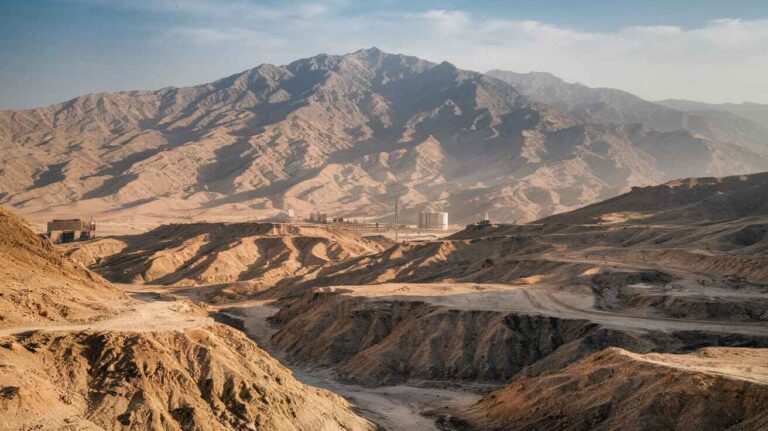
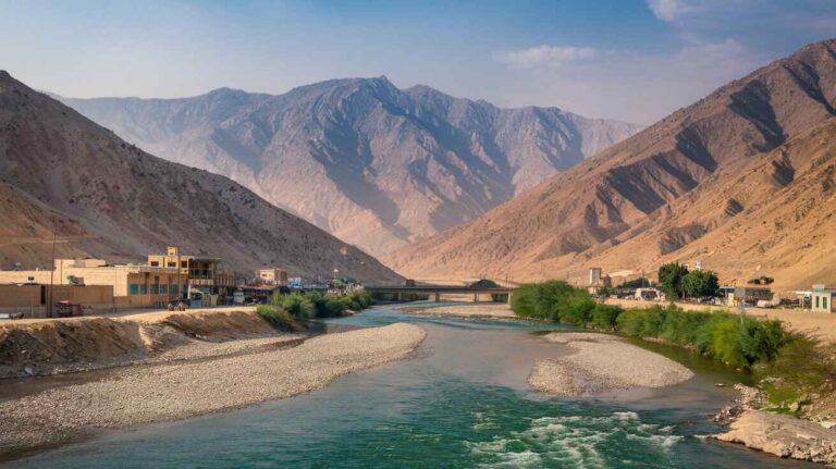
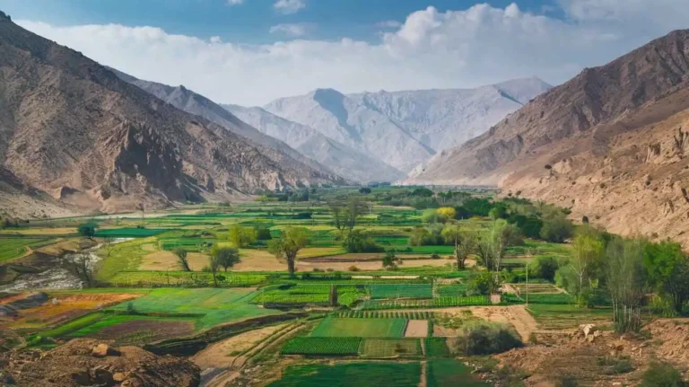
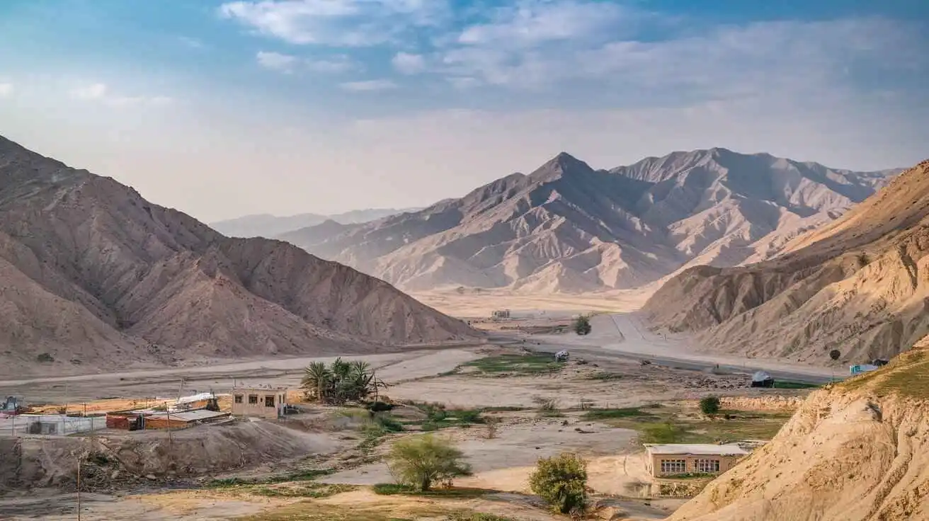
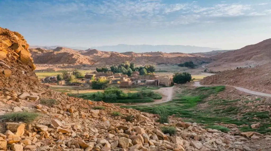
The topography of Barkhan is a mixture of plains, valleys, and mountains. The elevation ranges from 841 to 2,031 meters above Mean Sea Level (MSL). The landscape features the main Barkhan valley, along with several smaller valleys, all stretching in a southwest direction. The Barkhan valley is enclosed by scattered low hills to the north, which help direct drainage into the Rakhni stream. To the west, the Jandran range dominates the terrain, while the Vitakari valley marks the endpoint of the Barkhan valley.
Several other ranges also define Barkhan’s landscape, including the Sukha, Kharcha, and Phulai ranges. The Suleman range extends into Barkhan, with notable hills such as Kala Pahar, Karwada, Bibar, Jandra, Mar, Mukhmar, Andari, Sukha, Phulai, Khawaj, Mazara, Tagha, Dig, and Deka. The Han stream and its tributaries flow in a southwest direction, collecting water from the Han pass and the southeastern slopes of the Jandran range. This stream is perennial until it merges with the Kah River in Dera Ghazi Khan. Another important water source, the Dhaula stream, originates from the Bagha valley and irrigates villages before joining the Han stream in Vitakari. The Bala Dhaka stream, located in Berg-Sham Mauza, is a tributary of the Narechi River, which flows through Duki Tehsil, supplying irrigation to small agricultural lands.
Archaeological Sites
The district of Barkhan is rich in geological history, as evidenced by the discovery of dinosaur fossils during geological mapping and bio-stratigraphic research conducted by the Geological Survey of Pakistan (GSP). The most significant discovery was the Khetranisaurus, a dinosaur species that lived millions of years ago. The fossils were found in the Vatakari region of Barkhan, and the species was named to honor the Khetran tribe. The term saurus signifies reptiles, and the species’ name, barkhani, recognizes Barkhan as the host district of this remarkable discovery.
Climate
Barkhan has a hot, semi-arid climate under the Köppen classification BSh. The region experiences distinct seasons, with winters that are cool and summers that are extremely hot. Precipitation occurs in two key periods: light to moderate rain from February to April, and heavy monsoon rains from June to September. The record high temperature in Barkhan has reached 44.2°C (111.6°F), while the mean daily maximum temperature is 37.8°C (100.0°F). The daily mean temperature is 31.0°C (87.8°F), with a mean daily minimum of 24.4°C (75.9°F). The record low temperature has been -10°C (14°F). The annual precipitation averages 418.6mm (16.47 inches), according to NOAA data from 1971 to 1990.
Demographics
The population of Barkhan has evolved significantly over time. In 1951, the population was 103,545, growing to 171,025 in 2017 at a rate of 2.68% per year. The 2023 census recorded the population at 210,249, with a growth rate of 3.50%. The district consists of 23,053 households, with a sex ratio of 108.95 males per 100 females. The literacy rate remains low, with 41.63% males and 24.93% females being literate. The population under 10 years of age makes up 40.33% (84,790 children), while urban residents number 14,425, making up 6.86% of the total population.
Religion
The dominant religion in Barkhan is Islam, with 99.77% of the population adhering to it. Other religious groups include Christianity (0.22%), while Hinduism is virtually absent (0%). A small fraction (0.01%) identifies as Others. Historical data from 1941 recorded 96.24% Muslims, which increased to 99.95% by 2017, reaching 209,755 Muslims in 2023.
Languages
The Balochi language is the most widely spoken in Barkhan, accounting for 98.62% of the population. Other spoken languages include Saraiki (0.6%), Pashto (0.54%), and others (0.24%). The Khetrani language, an Indo-Aryan dialect, is also spoken by a significant community of native speakers.
Tribes and Society
The tribal structure of Barkhan consists of several influential groups, including the Khetran, Marri, Hasni, and Buzdar tribes. The Khetrans hold a dominant position in the district, with their Tumandar (chief) playing a key role in governance. Each sub-clan is represented by a Wadera (headman), ensuring tribal representation and governance at the local level. The tribes of Barkhan have maintained their cultural traditions and leadership structures, contributing to the region’s unique identity.
Barkhan is a district located in the province of Balochistan, Pakistan. It shares borders with Dera Bugti in the south, Musakhel in the north, Kohlu in the west, and Loralai along with Punjab on the eastern boundary. The headquarter of the district is Barkhan town, which was given the status of a separate district on December 31, 1991. Before that, it was part of Sibi and later became a tehsil under Loralai District. The name Barkhan is believed to have originated from Baron Khan, a leader of the Barozai family of Pannis, who ruled the area under the governance of Sibi.
According to the 1998 census, the population of Barkhan was 104,000, with males making up 53% and females 47%. The annual growth rate was recorded at 3.09%, and the projected population for 2015 was 174,467. The average household size was 6.8 persons per house, with the population density increasing from 29 per km² in 1998 to 42 per km² in 2010.
Wildlife Protected Areas
Despite its vast rangelands, Barkhan has no protected areas for wildlife or forests. The grasslands support a variety of plant species, including the dwarf mazri palm (Nannorhops ritcheana) and other steppic plantations, which serve as a livelihood for the local population.
Education Sector Plan
The Balochistan Education Sector Plan (BESP) guides the education policies in Barkhan at the district level. It focuses on access, equity, quality, governance, and management. The Constitution of Pakistan, under Article 25A, guarantees free and compulsory education for children aged 5 to 16 years. The Balochistan Free and Compulsory Education Act 2014 ensures that the government provides schoolbags, stationery, transport, and meals. Schools are open to every child, regardless of sex, race, nationality, or disability. The district is responsible for ensuring compulsory education, but challenges remain in governance structure and quality teaching.
Economic Endowments
The geographical area of Barkhan spans 351,000 hectares, with 39,215 hectares being uncultivable. The potential cultivation area is 83,435 hectares, making up 24% of the district. The Cultivable Waste Land ranged from 41,521 to 42,515 hectares between 2004-2009.
- Major Rabi crop: Wheat cultivated on 16,600 hectares (89%).
- Vegetables: 8.2% of the total area.
- Wheat production: 32,186 tons in 2008-09, with a yield of 1,939 kg/hectare.
- Major Kharif crop: Cotton cultivated on 3,731 hectares (33%).
- Vegetables: 11,377 hectares (22%).
- Irrigated area: 24% used for vegetables.
- Livestock population: Gradual increase.
- Gypsum reserves: 270 metric tons, though mineral exploitation remains unfeasible due to economic constraints.
Poverty & Child Labor
Barkhan faces issues of child labor, where children work in hotels, fodder cutting, wood and bush collection, and household activities like water fetching and embroidery work. The lack of education and poverty force children into early school dropout. Barkhan ranks among Balochistan’s least developed 19 districts in terms of child well-being index and underweight prevalence.
State of Education
The education sector in Barkhan struggles with access and quality issues due to poverty and cultural constraints.
- Total public schools: 610 (Primary, Middle, High, and Higher Secondary).
- 97% of schools are in rural areas, while only 3% are in urban areas.
- Literacy rates: 36% (10+ age group), 26% (15+ age group).
- Female literacy: 5% (15+ years), 11% (10+ years).
- School retention issues: Lack of water, toilets, and transition gaps from primary to middle and secondary to higher secondary levels.
- Annual Status of Education Report 2015 highlighted low survival and transition rates, as well as teaching-learning quality concerns.
District Mandate
The district unit is responsible for schools, teachers, and education quality delivery under Article 25A. However, Barkhan’s education offices lack capacity to implement free education, including meals, transport, and textbooks. The government also struggles to regulate private schools, adding to governance problems.
Financial Management
- District Education Officers (DEOs) and head teachers lack financial training, leading to dependency on support staff.
- Procurement processes have been decentralized to cluster levels, increasing the risk of corruption.
- Internal audit mechanisms are needed to ensure effective decentralization and reduce financial mismanagement.
Private Sector Regulation
- The private education sector in Barkhan accounts for 10% of total enrollment.
- No regulation exists under Article 25A.
- District authorities lack capacity to regulate private schools.
- Education laws are outdated (1961), needing revision under the Compulsory Education Act.
History of Barkhan
Barkhan was once a tehsil of Loralai, but in 1991, it was given the status of a district due to administrative needs. The headquarters of the district is Barkhan town, which became the center of governance after the administrative upgrade. The early history of Barkhan is closely linked to the rulers of Kandahar and India. Historical records suggest that it remained under Muslim rulers, including the governors of Sewistan (now Sehwan) and the Hind Province of Thatta.
In ancient times, Jat communities of Hindus inhabited the region alongside a Pathan tribe that migrated from Vehova in Dera Ghazi Khan. The leader of these settlers was Baro Muhammad Khan, who later became associated with the Khetrans, a community known as cultivators. The name Bar Khan was gradually transformed into Barkhan, and the area was recognized as Khetran Country. Even today, the Khetrans have a strong presence in Vehova city and surrounding areas.
According to oral history, during the time of Mughal Emperor Akbar (1542-1605), a man named Ram Sunara, a goldsmith, sought refuge among the Khetrans. However, he was a fugitive wanted by the Mughal Court, and when the emperor sent an army to retrieve him, the Khetrans resisted. A battle ensued, resulting in the Khetrans’ defeat. Many of them, under the leadership of Baro Khan, fled to an area then known as Janjah, which later became Barkhan.
The Barozai family of Pannis, rulers in Sibi, played a significant role in the early governance of Barkhan. Initially, the Lath Afghans oppressed the Khetrans, but they were later overpowered by the Mazarani clan, forcing the Lath to relocate to Luni Country (now Duki Tehsil). After a period of internal conflict, Girazo Khan Mazarani was appointed as the Khetran Chief. He was succeeded by his son Ikhtiar, who later passed leadership to Mir Haji Khan, a notable figure remembered for his victory against the Zhob Kakars.
Following Mir Haji Khan, the leadership of the Khetrans continued with Sayed Khan, then Babul Khan, though Babul Khan’s rule faced opposition from Nawab Khan and Kadir Bakhsh Khetrans. The opposition sought the support of the Marris, leading to conflict. This turmoil ultimately brought Barkhan under British control.
British Control and Colonial Rule
By 1880, the Khetrans sought British protection by submitting a petition to Sir Robert Sandeman, then Deputy Commissioner of Dera Ghazi Khan, offering to pay revenue in exchange for security. From 1878 to 1883, Barkhan was under the control of British authorities in Dera Ghazi Khan.
In 1883, Sardar Baloch Khan, the Chief of the Khetrans, met with Mr. Bruce, the Political Agent of Thal-Chotiali, along with a Jirga of his tribesmen to settle disputes with the Luni and Marri tribes. By 1884, the British Agent to the Governor General officially took control of Barkhan. The Leghari Barkhan circle, comprising Barkhan valley and Vitakari valley, was transferred from Punjab to Balochistan.
Administrative Changes and Political Developments
In 1887, Barkhan was brought under direct administration, and work on the D.G Khan-Pishin Road began. A Tehsildar was posted in the area to oversee governance. Later, in 1889, Barkhan tehsil was placed under the Zhob Agency, with Loralai serving as the headquarters. In 1892, it was transferred to the Thal-Chotiali Agency. In October 1903, British authorities restructured the region, placing Barkhan under Loralai Agency, while new agencies, including Sibi, Loralai, and Zhob, were formed.
Khetran Leadership and British Policies
During the British period, Sardar Mehrab Khan, born in 1853, succeeded his father, Sardar Baluch Khan, as the Chief of the Khetrans. He was later succeeded by Shah Ghazi Khan in 1942, followed by Muhammad Anwar Jan, who was elected to the Provincial Assembly in 1970. Eventually, on December 31, 1991, Barkhan was declared an independent district, with Barkhan city as its headquarters.
Governmental Structure
Today, Barkhan is represented at the Federal level by 1 seat in the National Assembly and 1 seat in the Provincial Assembly. Under the Local Government Act 2010 (amended in 2011), Barkhan has 1 District Council, 1 Municipal Committee, and 8 Union Councils. Representation includes 33% seats for women, 5% for workers, and 5% for peasants.
Administrative Divisions
With a total area of 3,514 km², Barkhan is administratively divided into 1 tehsil, known as Barkhan tehsil, which consists of 8 Union Councils.
Heritage and Tourism
Despite its historical significance, Barkhan has no officially recognized historical or heritage sites and lacks designated tourist areas.
British Raj and Conflicts
During the British era, Barkhan witnessed conflicts among the Khetrans, Lunis, and Marris. The 1880 petition to the British authorities at Dera Ghazi Khan marked a turning point. In 1883, Sardar Baloch Khan met with Mr. Bruce, the Political Agent of Thal-Chotiali, and settled disputes through a Jirga.
The Leghari Barkhan circle, which included the Barkhan valley and Vitakari valley, was transferred from Punjab to Balochistan in 1884. In 1887, with the construction of the D.G Khan-Pishin Road, a Tehsildar was appointed to Barkhan. In 1889, it was placed under the Zhob Agency, with Loralai as the headquarters, before being moved to the Thal-Chotiali Agency in 1892. The final administrative restructuring in October 1903 placed Barkhan under the Loralai Agency.
Khetran Leadership and Internal Struggles
The Khetrans were led by prominent chiefs like Mir Girazo Khan, Bakhtiar Khan, and Mir Haji Khan, who famously defeated the Zhob Kakars and later retaliated against the Marris by destroying the Mawand fort of Karam Khan Bijrani Marri.
Haji Khan left behind three sons: Umar Khan, Nawab Khan, and Balu Khan. However, his brother Sayed Khan was elected as the next chief. His rule was followed by Dost Muhammad, Sorni Khan, and Kadir Bakhsh. Later, Babul Khan faced opposition from Kadir Bakhsh, who allied with the Marris. The Marri Chief Gazan supported him in battle, but Sir Robert Sandeman intervened to restore order in the region.
Conclusion
The history of Barkhan is filled with power struggles, British interventions, and local conflicts. The district’s transformation from a tehsil to a district reflects its strategic importance and rich heritage, even though it lacks official historical sites today.