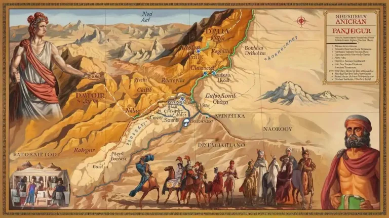
Ziarat: A Jewel in Balochistan
Ziarat
The Enchanting Beauty of Ziarat
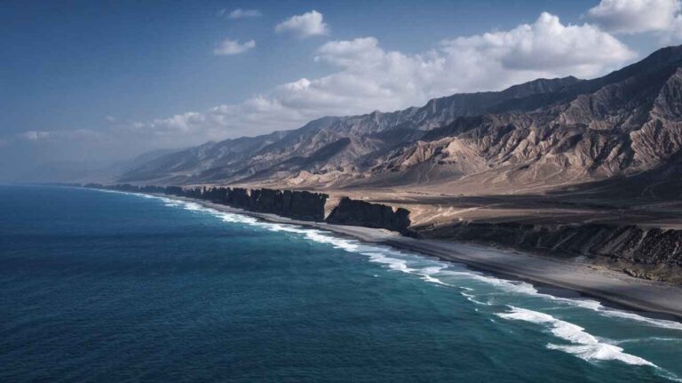
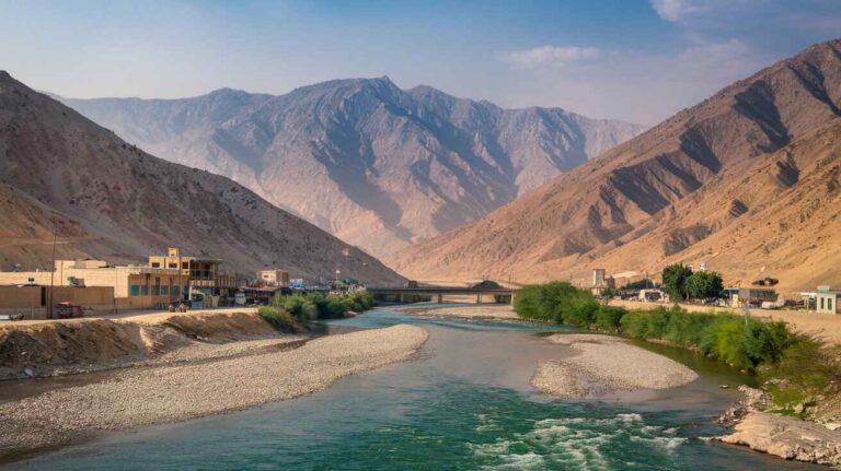
Nestled in the north of Balochistan province, Pakistan, Ziarat is a place of breathtaking landscapes and historical significance. It is the district headquarters, located at an altitude of 2,400 meters, making it one of the highest towns in Pakistan. The district is known for its scenic mountains, with Khalifat Hills, the highest peak, rising to 11,400 feet (3,500 m) above sea level. The tehsil of Ziarat town is a hub of nature and culture, offering a peaceful retreat for travelers and adventure seekers alike.
Administrative Structure of Ziarat District
The Ziarat District was established in July 1986 after being separated from Sibi District. According to the latest census, the population stands at 52,855. The district is subdivided into two tehsils, Ziarat and Sanjawi. Among these, Ziarat tehsil is densely populated, with 32,456 residents, while Sanjawi tehsil has 18,000 people. The district is further divided into ten Union Councils, with administrative structures ensuring proper governance and development.
Demographic Insights
Over the years, the population of Ziarat has experienced significant growth. In 1961, the population was 15,853, which increased to 37,688 in 1972 at a rate of 8.19% per year. By 1981, it had grown to 63,179, marking a 5.91% increase. The 1998 census recorded 80,748 people, and by 2017, the population had doubled to 160,095 with an annual growth rate of 3.67%. The most recent census of 2023 reports a population of 189,535, reflecting a 2.85% increase per year.
Population Distribution and Literacy Rate
The district consists of 22,894 households, with a sex ratio of 103.02 males per 100 females. The literacy rate has seen gradual improvement, currently standing at 43.37%, with 53.06% males and 33.49% females being literate. About 41.63% of the 78,905 individuals are under 10 years of age. The urban population is minimal, with only 684 residents (0.36%) living in urban areas.
Cultural and Linguistic Identity
The majority of the people in Ziarat speak Pashto, which is the predominant language, spoken by 98.85% of the population. Religious minorities, including Christians and Hindus, constitute a small fraction of the total population. Despite cultural diversity, the residents of Ziarat have maintained their traditions and heritage over the years.
A Thriving Tourist Destination
Ziarat is renowned as a tourist destination, drawing visitors due to its unique natural beauty. The district is famous for its juniper forests, which are some of the oldest in the world. The lush green valleys and breathtaking landscapes make it a favorite spot for nature lovers. The tourism sector significantly contributes to the economy, creating jobs and business opportunities for the local population.
The Abundance of Orchards
The fertile lands of Ziarat support a thriving agricultural sector, particularly orchards that produce high-quality apples and cherries. These fruits are not only consumed locally but are also exported to other parts of Pakistan, boosting the economy and supporting the livelihoods of many families.
Human Development Index in Ziarat
Despite being a remote area, Ziarat has one of the highest rankings on the Human Development Index in Balochistan province. The quality of life, access to education, and healthcare facilities have improved over time, making it a relatively developed district compared to other regions in the province.
The Historical Significance of Ziarat Residency
One of the most iconic landmarks in Ziarat is the Ziarat Residency, where Governor-General of Pakistan, Muhammad Ali Jinnah, spent the last days of his life. This historical site holds great importance in the history of Pakistan and attracts visitors who wish to pay homage to the Father of the Nation.
A Place of Peace and Serenity
Beyond its historical and natural attractions, Ziarat offers an atmosphere of peace and tranquility. The cool climate, fresh mountain air, and friendly locals make it a perfect getaway for those seeking relaxation and adventure at the same time.
Future Prospects of Ziarat
With continuous development in infrastructure and tourism, Ziarat has the potential to become a leading travel destination in Pakistan. Investment in ecotourism and preservation of natural resources will ensure that future generations can enjoy the beauty and history of this remarkable region.
Ziarat is more than just a tourist spot—it is a region of cultural significance, economic potential, and natural splendor. With a rich history, stunning landscapes, and a growing economy, it continues to be a jewel in the heart of Balochistan province, Pakistan.
A Glimpse into Ziarat
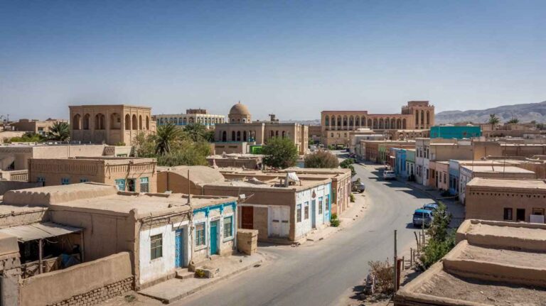
Nestled in Balochistan, Ziarat is a beautiful city known for its breathtaking valley and rich history. It serves as the district headquarters of Ziarat District and is a well-known tourist destination. Located near Quetta, the provincial capital, it holds immense historical importance. The founder of Pakistan, Quaid-e-Azam, spent his last days in Quaid-e-Azam Residency, making it a cherished landmark.
Initially part of Sibi District, Ziarat was officially separated on 1st July 1986, becoming its own district. It shares borders with Pishin, Loralai, Killa Saifullah, and Sibi. Within the district, Sanjawi Tehsil is another notable area. Despite being one of the smallest districts, covering 3,670 km², its scenic beauty attracts visitors from across the country.
According to the 2001 census, the population of Ziarat District stood at 160,422 persons, with a Population Density of 49.1 persons/km². The Population Growth Rate was recorded at 3.7%, with Male Population at 51.3% and Female Population at 48.7%. However, the Urban Population remains quite low at just 2.1%.
Administratively, the district is divided into Tehsils/Talukas, with Sanjawi being one of the main towns. Apart from Ziarat Town, there are several villages, including Kawas, Zandra, Spezandi, Choom, Zargi, Tand Wani, Khaza, Uchwani, Smallan, and Aghbarg. These settlements reflect the traditional and rural lifestyle of the region.
The Literacy Rate in Ziarat is around 39.0%, with a notable gap between genders. The Male Literacy Rate is 55.0%, whereas the Female Literacy Rate lags at 21.0%. This highlights the need for better educational facilities, especially for women.
Economic activity in Ziarat is primarily based on agriculture, livestock breeding, fishing, and hunting, contributing 45.9% to the local economy. Other significant sectors include community services (32.0%), construction (9.6%), and electricity, gas, and water supply (4.2%), while 8.4% of the population is engaged in miscellaneous occupations.
The fertile land of Ziarat supports the cultivation of crops like wheat, barley, rapeseed, mustard, jowar, bajra, moong, and maash. The region is also famous for its fruits, including almonds, apples, apricots, grapes, peaches, pomegranates, cherries, and melons. Additionally, vegetables such as onions, potatoes, carrots, chilies, tomatoes, pumpkins, peas, and garlic are widely grown.
One of the district’s most valuable assets is its forests, covering 51,313 hectares. These forests not only support biodiversity but also play a crucial role in maintaining the region’s climate. Infrastructure development includes 537.0 km of metalled roads and 337.0 km of shingle roads, improving connectivity across the region.
Electricity in Ziarat is supplied by Quetta Electric Supply Company (QESCO). There are three telephone exchanges operating in the district, supporting 362 landlines, 341 wireless phones, and 336 broadband connections. Despite these facilities, the region still lacks Industrial Zones or Major Manufacturing Industries, with only a few flour mills operating locally.
The average household size in Ziarat is 7.4 persons per house. However, only 13.2% of houses have piped water, while 81.9% of homes have access to electricity. These figures indicate a need for better water supply infrastructure.
With its scenic landscapes, historical significance, and thriving agriculture, Ziarat remains one of Balochistan’s most fascinating districts.

Ziarat: A Land of Natural Beauty and Economic Potential
The Economic Landscape of Ziarat District
The Ziarat District is not only known for its breathtaking landscapes but also for its growing economic activities. Among the key sectors contributing to the local economy are Poultry Farms, Fishing, Bee Keeping, Irrigation Network, Forestry, Mining, Industry and Manufacturing, Trade, Handicrafts, and Economic Infrastructure. These sectors have shaped the region’s development and provided livelihood opportunities to many.
Poultry Farms in Ziarat District
In recent years, poultry farms have emerged as a crucial economic activity in Ziarat District. The region’s climate and increasing demand for poultry products have encouraged many farmers to invest in this sector. The available data suggests a steady rise in the number of farms, catering to both local and provincial markets. The expansion of this industry has not only boosted the economy but also created employment opportunities for the local population.
Fishing in Ziarat District
Though not traditionally known for fishing, Ziarat District has great potential in inland fishing due to its cold-water fish resources. The presence of streams in areas like Sanjawi offers opportunities for a developed economic activity in this sector. With proper investment and support, fishing can become a sustainable income source for the local communities.
Bee Keeping in Ziarat District
Bee keeping has been a reasonable economic activity in Ziarat for many years. The region’s climate and natural flora make it an ideal place for honey production. Local vendors set up makeshift stalls to sell locally produced honey, attracting both locals and tourists visiting the area. With its market potential and scope for export, this industry can further strengthen the district’s economy.
Irrigation Network in Ziarat District
Agriculture remains an essential part of Ziarat District‘s economy, relying heavily on its Irrigation Network. The cultivated area is irrigated through multiple sources, including open wells, tube wells, karezes, and springs. According to Balochistan Development Statistics 2018-19, the total irrigated area in Ziarat is 6,553 HA, with private canal irrigation covering 2,503 HA, tube wells 3,720 HA, and karezes 330 HA. Additionally, small dams help in maintaining a steady water supply for agriculture. The Official IUCN Website highlights areas like Mara Sund, Ghara, Haji Toor, Churman, Inzerget, Poi Bano Bagh, and Chashma as key irrigation sites.
Forests in Ziarat
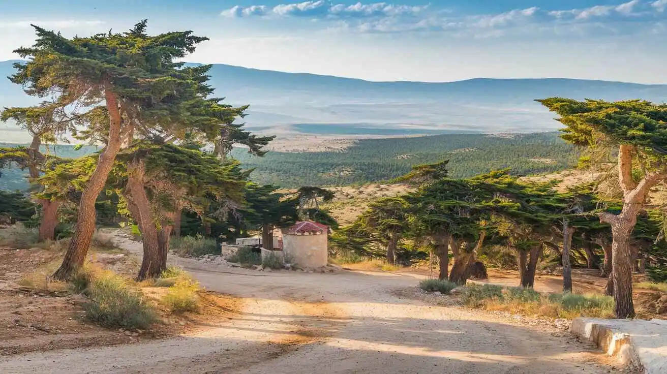
One of Ziarat’s distinctions is its possession of the second-largest juniper forests in the world. The Juniperus excelsa forests, stretching into Harnai and Quetta, hold global importance due to their unique ecosystem and biodiversity. These forests are a potential World Heritage Site and serve as a natural treasure. There are 15 notified natural sites, including Bastirgi, Gohar, Zargat, Sasanamana, Shaeedan, Pil Wam, Tangi Kach, Mangi Nallah, Surghund, Chasnak, Chautair, and Kurbi, covering 61,731 HA.
According to Balochistan Development Statistics 2018-19, the total forest area in Ziarat is 126,797 HA, including scrub, rangelands, coniferous, irrigated, riverine, and coastal mangrove forests. Tree species include Turkestan Juniperus excelsa polycarpos, wild ash (Fraxinus xanthoxyloides), Pistacia khinjuk, olive (Olea ferruginea), mazri (Nannorrhops ritchieana), and various shrubs and grasses. These forests not only provide environmental benefits but also contribute to the local economy through timber and non-timber products.
Mining in Ziarat District
The Ziarat District Development Profile 2011, published by P&D, GoB, and UNICEF, highlights significant mining potential in the region. The district is known for marble and dimension stones, which are mined by the private sector. Other minerals found include coal, laterite, titanium, and calcite. The Geological Survey of Pakistan has also explored potential oil and gas deposits in the area, which could contribute significantly to the economy in the future.
Industry and Manufacturing in Ziarat District
The manufacturing sector in Ziarat District is limited but growing. The presence of milling units caters to the local demand for essential goods. The district also has flour mills, motor car and cycle workshops, and artisan shops, contributing to small-scale industrial development.
Trade in Ziarat District
While large-scale trade is still developing in Ziarat District, small businesses play a crucial role in supporting the economy. Agricultural products, handicrafts, and locally mined materials are traded within and outside the region.
Handicrafts in Ziarat District
Traditional handicrafts in Ziarat District include household items made from mazri palm leaves, rugs from goat hair, and sacks made of hides and skin. The region is also known for its cottage industries, including goldsmiths, carpentry, pottery, and woolen carpets. These goods have potential for expansion into national and international markets.
Economic Infrastructure in Ziarat District
The roads in Ziarat District form the transport backbone of its economy, but the infrastructure remains poor in certain areas. Many roads are shingle, making travel difficult. The black-topped roads connecting the district with Quetta and Karachi are crucial for trade and tourism. Electricity is supplied by Quetta Electric Supply Company (QESCO), but natural gas remains unavailable, limiting industrial expansion.
Road Statistics in Ziarat District
According to Balochistan Development Statistics 2018-19, the total roads in Ziarat District span 874.0 km, comprising 537.0 km high-type roads and 337.0 km low-type roads. The Quetta-Ziarat National Highway (N-50) connects the district with Kuchlak, Dera Ismail Khan, Harnai, Pishin, and Loralai.
Rails and Airways in Ziarat District
Currently, there are no railway or airline services within Ziarat District. The nearest railway station and airport are located in Quetta, making it the primary transport hub for the district.
Radio and Television in Ziarat District
Residents of Ziarat District access TV and radio broadcasting through channels from Karachi, Quetta, Islamabad, Zahidan (Iran), and Kabul (Afghanistan). BBC and other international stations can also be heard via cable services.
Telecommunications in Ziarat District
Ziarat District is connected to Pakistan and the world through a modern digital telephone exchange. The district has 362 landlines, 341 wireless connections, and 336 broadband users, along with cellular services in key towns.
Post Offices in Ziarat District
The district has 05 post offices, along with courier companies offering postal services.
Banking and Financial Services in Ziarat District
The district has banks, including National Bank of Pakistan Ltd and Zarai Taraqiati Bank, with 03 conventional branches and 02 Islamic banking branches.
Electricity and Gas in Ziarat District
Electricity is supplied by Quetta Electric Supply Company (QESCO), but natural gas remains unavailable, affecting household and industrial growth.
Ziarat: A Land of Natural Beauty and History
A Glimpse into Ziarat’s Past
Ziarat is a beautiful city in Ziarat District, located 130 kilometres from Quetta, the provincial capital of Balochistan, Pakistan. It became a separated district on 1st July 1986, marking its distinct identity. This region holds great historical and cultural value, being the final resting place of Quaid-e-Azam Muhammad Ali Jinnah, the founder of Pakistan. His last days were spent at the Quaid-e-Azam Residency, a landmark of national importance.
The history of Ziarat dates back to ancient times when it was a spiritual center. The region is home to the shrine of Mian Abdul Hakim, famously known as Kharwari Baba, a revered Muslim Saint. Legends tell that this Saint performed miracles and brought prosperity to the area, making it a place of pilgrimage. People from nearby regions, including Kandahar, Afghanistan, and across Balochistan, come to pay their respects.
This area is also known for its historical associations with the Panri tribe, which played a significant role during the Anglo-Afghan War of 1839. One of the prominent tribal figures, Misri Khan, was a respected ruler of his time. The British, during their expansion, sought the allegiance of local tribesmen, incorporating them into the Baloch Levy. Over time, Ziarat became a central hub under British rule, leading to the establishment of a sanatorium in 1886. By 1887, the Residency building was constructed, further strengthening the association between Ziarat and Jinnah.
The Administrative Framework of Ziarat
At the federal level, Ziarat District has representatives in both the National Assembly and the Provincial Assembly. The district has one seat in the National Assembly, while at the provincial level, governance follows the Local Government Act 2010, which was amended in 2011. The District Council oversees the 14 Union Councils, ensuring fair representation. The Municipal Committee of Ziarat manages urban affairs, with 33% seats reserved for women and 5% seats for workers and peasants.
Administratively, Ziarat District covers a total area of 3,670 km² and is divided into two tehsils: Ziarat Tehsil and Sanjawi Tehsil. Ziarat Tehsil consists of three Union Councils, while Sanjawi Tehsil has four Union Councils.
The Beauty and Attractions of Ziarat
Ziarat is a treasure trove of tourism, offering both picnic and archaeological spots. One of its most famous natural wonders is the Juniper Forests, which spread across the region. These forests are home to the Juniperus seravschanica, some of the oldest trees in the world, dating back 4,000 years. The forest covers an area of 110,000 hectares, making it the second-largest juniper forest globally. The scenic landscape, seasonal snowfall, and lush orchards add to its charm.
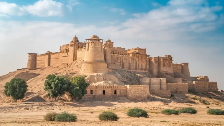
The Quaid-e-Azam Ziarat Residency is a symbol of national heritage. This historical building was declared a protected site under the Antiquities Act of 1975. Originally built in 1903, it served as the summer residence of the Assistant Governor General of Balochistan. It is constructed using limestone, with beautiful porches, balconies, and teakwood designs.
For adventure lovers, Khalifat Peak, the second-highest peak in Balochistan, provides opportunities for mountaineering and trekking. The Chashma Walk, with its mile-long flat land, offers a peaceful walk through the hills and ravines. The springs, or chashma, in this area provide fresh water to the town.
Sacred Shrines and Pilgrimage Sites
Among the significant shrines in Ziarat is the sacred resting place of Baba Kharwari, located 8 km from Ziarat Town. He was a disciple of Nana Sahib, and his miracles continue to attract pilgrims. Another revered site is the Nau Gaza Baba shrine, which is known for its historical importance. The Abdul Kareem shrine, with its 9-yard-long tomb, is also a place of spiritual significance.
Festivals and Cultural Events
The Ziarat Week, an annual festival, is celebrated with great enthusiasm. Organized by the Ziarat Social Welfare Society under the supervision of the Deputy Commissioner, the event includes various sports tournaments, such as cricket, football, volleyball, wrestling, and a cycle race. Other traditional activities include tug-of-war, marksmanship, and wrestling competitions. The event attracts visitors from all over Balochistan, making it a significant cultural celebration.
The Tragedy of 2008: The Ziarat Earthquake
On 29 October 2008, tragedy struck Ziarat when a 6.4-magnitude earthquake caused immense destruction. The tremors, which lasted only 30 seconds, led to the collapse of many mud houses, government buildings, and even parts of the villages surrounding the town. The Pakistani military helicopters were deployed for emergency relief efforts. Reports from the US Geological Survey indicated that the earthquake originated 60 km from Quetta, with a moment magnitude of 6.4. The disaster resulted in over 200 deaths, with 50,000 people left homeless due to landslides blocking access to affected areas.
Geological Background and Earthquake Impact
The tectonic summary of western and northern Pakistan shows that the Indian plate is continuously moving towards the Eurasian plate at a rate of 40 mm per year. The Chaman Fault plays a significant role in the seismic activity of the region. Historically, the 1935 Quetta earthquake caused over 30,000 deaths, and similar seismic activities have continued to threaten the region. The earthquake sequence of 28 October 2008 included a foreshock of magnitude 5.3, followed by a doublet earthquake of magnitude 6.4, causing severe structural damage.
Damage and Response
Following the disaster, emergency relief efforts were carried out by the Balochistan chief minister, Aslam Raisani, and local authorities. The difficult terrain, landslides, and collapsed mud houses made rescue operations challenging. Hospitals in Quetta, Ziarat, Pishin, and Loralai were overwhelmed with injured victims. The mayor, Dilawar Kakar, coordinated a larger operation to support displaced families.
The Scientific Perspective
The moment magnitude scale (MMS), introduced by Thomas C. Hanks and Hiroo Kanamori in 1979, replaced the older Richter scale (ML). The Richter scale, developed in 1935, was a logarithmic scale primarily used for measuring small earthquakes. Today, the United States Geological Survey (USGS) relies on the moment magnitude scale for M > 4 earthquakes, making it an authoritative ranking system.