
Kholo: An In-Depth Exploration
Kholo
Geographical Features of Kohlu District
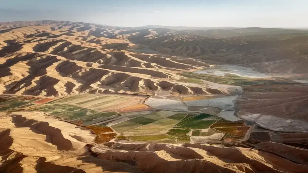
Kohlu district is an expansive geographical area situated in Balochistan, with a total geographical area that spans vast terrains. According to the Agricultural Statistics of Balochistan 1994-95, the reported area covers a significant portion, while some parts remain area not reported due to inaccessibility. The district has a considerable extent of arable land, offering great potential for cultivation. However, large stretches of land remain culturable waste due to factors like water logging and salinity. Unlike other regions, Kohlu is almost entirely devoid of forest and woodlands, limiting the availability of timber and fuel wood for its inhabitants. A major segment of the land falls under the category of area not available for cultivation, reducing the effective district area used for farming. There is minimal area under forest, while some portions serve as permanent pasture. The distribution of land use, measured in hectares and percentage, reflects the challenges and opportunities in agricultural development.
Topographical Landscape and Physical Features
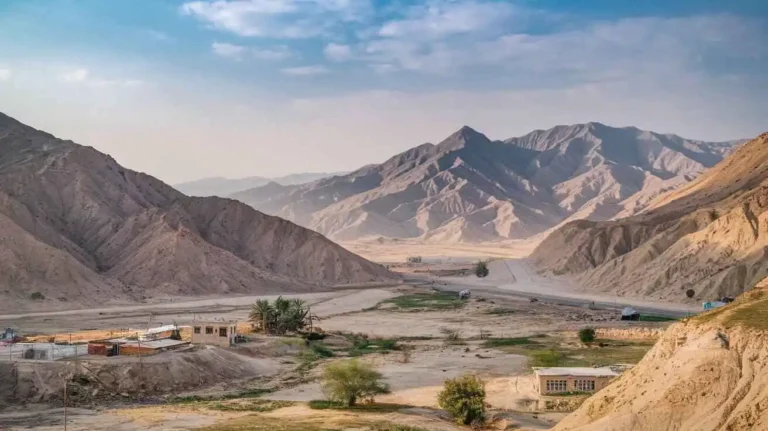
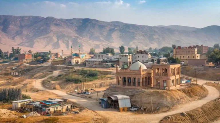
Kohlu lies at specific north latitudes and east longitudes, bordered by Loralai district, Barkhan district, Dera Bugti district, Bolan district, and Sibi district. Covering a total area of several square kilometres, the district extends toward the southern end of the Sulaiman range, featuring narrow parallel ridges and undulating hills. The region consists of the Sulaiman plateau, vast plains, and deep hill torrents that form intricate ravines. The terrain is largely barren and rugged, interspersed with valleys such as Kohlu, Kahan, Tadri, Daho, Bambor, Pheawagh, Nesao, Janatali, Mawand, and Gamboli. Distinct limestone ridges and parallel valleys define the geography, with notable landforms like Dungan, Lakar, Sialu, Tikil, Tikhil, Batur, Jandran, Bibartak, Siah Koh, Kup, Chappar, Sir Ani, Shatrak, Turki Koh, Tatra, and Rastrani. The Danda range, Nafusk, Bambor, and Gurandani also contribute to the district’s diverse landscape. Several principal passes, including Bibartak, Wanga, Narial, Mezhliar, Sinni, Ormazhi, Bar, Nari, Kuchali, Spintangi, Arand, Angur, Sembar, Pazha, Kuba Wanga, Bala Dhaka, Mar, Vitakri, Lunial, Bor, Kui, Dojamak, Dangar, and Nafusk, serve as vital connections within the district. The Marri and Bugti tribal areas are also integral to the region. Water sources include streams such as Nesao, Phelawagh, and Janatali, and rivers like Lahri, Bor, Rod Baladhaka, Rod Barg, Beji, Dada, and Nari. Seasonal flooding occurs in Kahan valleys, Tratani, and other low-lying areas, impacting land usability.
Climatic Conditions and Environmental Factors
Kohlu’s elevation is several meters above sea level, influencing its arid climate. The district experiences warm summer and cool winter, with significant fluctuations in temperature. The mean temperatures range from 21°C to 32°C, with June recorded as the hottest month, reaching up to 38°C during summer. In contrast, the winter months can be particularly cold, with January often dipping to 10°C or even near the freezing point. Occasionally, the region experiences cold spells, where temperatures drop below 0°C. Rainfall remains limited, with annual precipitation generally below 250 mm. However, monsoon effects bring slight variations in precipitation levels, affecting vegetation and water availability. Historical data from the Pakistan Meteorological Department, 1995, shows an annual rainfall of 429.7 mm in Kohlu, whereas Barkhan district, monitored by a nearby meteorological station, records a higher annual rainfall of 512.5 mm. The potential evaporation rate remains high, exacerbating the district’s arid conditions. Geographical features significantly impact rainfall distribution, making water management a key challenge for the region’s agricultural sustainability.
Kholo: A Demographic Perspective
Kholo, located in Kohlu, is a region known for its distinct geographical and demographic features. Covering an area of 7,610 sq. km., it has witnessed changes in population over time. According to the 2017 census, the total population of the district was 213,933, with 112,124 male and 101,809 female inhabitants. The sex ratio stood at 110.13, indicating a slightly higher number of males than females. Compared to the 1998 census, the growth rate has been recorded at 4.08%, reflecting a steady increase. The population density remains low due to the vast land area, with rural settlements being more dominant than urban localities.
The district is divided into tehsils and sub-tehsils, including Grisani, Kahan, Kohlu, Mawand, and Tamboo. Among them, Kohlu remains the most densely populated, housing a significant portion of the total households. The urban proportion of the population is relatively small, with most people residing in scattered rural communities. In areas like Grisani and Kahan, the average household size varies, but overall, it remains higher than the national average. The availability of basic services such as electricity, water, and communication infrastructure is unevenly distributed across different regions.
The number of households in the district reflects the distribution of resources and access to information. In rural areas, 15,161 households have limited access to modern communication tools, while in urban areas, 6,606 households have better connectivity. Among sources of information, radio, television, newspaper, telephone, mobile, computer, and internet are available but not evenly spread. Only 4,056 rural households and 742 urban households own televisions, while newspapers reach around 1,151 rural and 536 urban homes. The use of mobile phones has expanded significantly, with 13,127 rural and 6,450 urban users. However, access to the internet remains restricted, as only 2,895 rural and 522 urban households have connectivity.
Population distribution varies across different localities, with settlements classified based on size. Areas with populations ranging from 10,000 to 24,999 are categorized as mc tehsil, while smaller settlements fall into different classifications. Some of the largest localities include 17,443 in one settlement, followed by 9,001 in another, and 8,442 in another area. The growth rate of these settlements has remained stable over the years, with fluctuations depending on migration and natural population increase.
The district has seen a significant rise in the adoption of modern technology. In rural areas, around 2,034 households own computers, compared to 156 in urban areas. However, reliable internet access is limited, with only 1,161 rural and 220 urban households having stable connections. The reliance on traditional media like radio and newspapers remains prevalent, especially in isolated regions. Interestingly, about 2,004 rural and 168 urban households still use radio as their primary source of information.
Despite the challenges, the people of Kohlu continue to adapt to modern advancements. The availability of mobile services has increased communication within the district, even in the most remote areas. The expansion of infrastructure, education, and employment opportunities could further improve the region’s overall development.
Kohlu District: Geography and Demographics
Kohlu District is an important region in Balochistan, known for its rugged terrain and strategic location. Situated between 29° 13Ꞌ 03” and 30° 04Ꞌ 15” north latitudes and 68° 05Ꞌ 49” to 69° 38Ꞌ 46” east longitudes, it shares borders with Loralai, Barkhan, Dera Bugti, Bolan, and Sibi. The district spans 7,610 km2 and has a population of 214,350 people. With a population density of 27.9 persons per km2, it has a growth rate of 4.1%, reflecting steady development over the years.
The Kohlu Agency consists of three Tehsils: Kohlu Tehsil, Mawand Tehsil, and Kahan Tehsil, each with its unique landscape and economic activities. The district includes settlements like Mawand, Karam Khan Shaher, Nisao, Pazza, and Sufaid. A significant portion of the population resides in rural areas, while the urban proportion remains 8.1%. The male population makes up 52.3%, while the female population is 47.7%.
Economic Activities and Agriculture
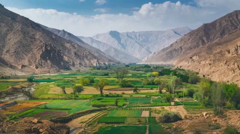
Agriculture and livestock breeding are the main sources of livelihood in Kohlu District, engaging 47.7% of the workforce. Other economic sectors include community, social, and personal services (17.7%), construction (15.1%), and electricity, gas, and water supply (15.1%). Crops such as wheat, barley, jowar, bajra, maize, mung, maash, moath, cotton, sunflower, tobacco, and fodder are cultivated here. Fruit farming is also significant, producing almonds, apples, apricots, grapes, peaches, pomegranates, plums, watermelon, musk melon, cherries, mangoes, and citrus. Vegetables like onions, potatoes, tomatoes, carrots, chilies, garlic, and coriander are grown, along with alfalfa as fodder.
Despite its agricultural potential, the district faces limited industrial development, with no major industries or industrial zones. The household size averages 6.5 persons, with only 7.1% of houses having piped water and 13.9% having electricity.
Infrastructure and Connectivity
The transport network includes 158.0 km of black-topped roads and 1,192.0 km of shingle roads, linking Kohlu with other districts. Electricity transmission and distribution are managed by Quetta Electric Supply Company (QESCO). There are four telephone exchanges, with 517 landlines, 457 wireless connections, and 402 broadband users. The availability of internet and mobile services is gradually improving, but many rural areas still lack reliable connectivity.
Topography and Natural Features
The topography of Kohlu District is dominated by the Suleiman Mountain Range, characterized by narrow, parallel ridges, rugged hills, and deep ravines. It is home to limestone ridges and valleys, with the eastern half featuring areas like Katarmari, Mar, Jandran, Makhmar, Nisau, and Kahan, while the western half includes Bambor Ghar.
Some of the highest peaks in the region include Dungan (2,091 m), Lakar (2,078 m), Sialu (2,473 m), Tikil (2,099 m), Batur (1,751 m), Jandran (2,050 m), Bibartak (1,916 m), and Siah Koh (1,678 m). Other notable ranges include Kup Chappar (1,425 m), Sir Ani (1,155 m), Shatrak (1,158 m), Turki Koh (1,225 m), Rastrani (914-1,219 m), and Nafusk (1,145 m). The Bambor (1,490 m), Gurandani (1,716 m), and Sunari (1,750 m) ranges also shape the landscape.
Settlements and Road Networks
Key settlements in Kohlu District include Wanga, Narial, Mezhliar, Sinni, Ormazhi, Bar, Nari, Kuchali, and Spintangi. The Sibi-Harnai road connects the district with other parts of Balochistan. Important locations like Arand, Khajak, Kot Mandai, Angur, Gamboli, Sembar, Beji, Thal, Kuba Wanga, Bala Dhaka, Mar, Vitakri, Lunial, Bor, Kui, and Dojamak add to the district’s geographical diversity. The Kohlu-Kahan road is a crucial route that facilitates movement within the district.
Census and Statistical Data
The 2017 Census and previous records from 1998 provide demographic insights, supported by surveys like Pakistan Social & Living Measurement Survey (PSLM) 2014-15, Balochistan Development Statistics 2018-19, and the District Development Profile 2011. These sources, compiled by the Planning & Development Department, Government of Balochistan (GoB) and UNICEF, offer valuable information about the district’s socio-economic conditions.
Challenges and Development Needs
Despite its rich natural resources and agricultural productivity, Kohlu District faces challenges in infrastructure, education, and industrial growth. The literacy rate remains 32%, with male literacy at 50% and female literacy at only 12%. Improved access to electricity, water, and internet is crucial for development. Enhanced road networks and investment in healthcare and education could uplift the district’s living standards.
Cultural and Social Aspects
The people of Kohlu District have a strong sense of community and tradition. Many are engaged in fishing, hunting, and livestock farming, preserving their ancestral ways of life. The region’s cultural heritage is deeply rooted in tribal customs, with hospitality being a significant part of daily interactions.
Kohlu’s natural beauty, agricultural potential, and strategic location make it an important district in Balochistan. With better infrastructure and development projects, it has the potential to emerge as a more economically vibrant and socially progressive region.
Rivers, Streams, and Lakes of Kohlu District
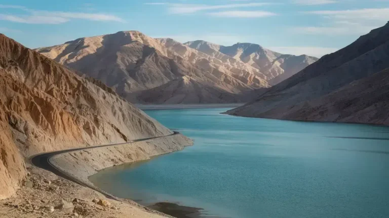
Water plays a crucial role in Kohlu District, shaping its landscape and supporting life. The rivers, streams, and lakes in the region serve as the primary water supply for both humans and animals. The Kohlu Valley is traversed by multiple tributary channels that carry perennial water, ensuring a stable source of drinking water. Among these are Beji, Rod Baladhaka, Sundimari, Siti, Phelawagh, and Suri Kaur, which flow through different terrains of the district.
The east and west regions of Kohlu contain a network of nullahs and affluents that drain the area. Significant watercourses include Karmari, Lahri, Jandran, Nisoba Nala, Sor, Nesao, Tirchi Otak, and Doda, each playing a vital role in the district’s water reservoir system. Additionally, Chakar Thank, Rod Barg, and Nal contribute to agricultural irrigation, preventing the land from drying out completely.
The Kahan Valleys and Makhmar region experience intermittent water flow due to seasonal variations, yet these sources remain critical for sustaining life. Additionally, the district has constructed a small dam to store water for periods of scarcity. The presence of larger water bodies in the bordering hills further ensures the availability of water, allowing for a flow of resources that supports the region’s diverse ecosystem.
Forests of Kohlu District
The natural beauty of Kohlu is enriched by its overall natural vegetation, consisting of trees, plants, grasses, bushes, and shrubs that make up the district’s rangelands. The forests here are classified as dry sub-tropical scrub forests, with some areas featuring tropical thorn forests. These forests are essential for maintaining ecological balance and providing fodder for local livestock.
Among the notable plant species in Kohlu are Angur, Gulab, Marshmallow, Dwarf Sophora, Periploca Aphylla, Suæda Fruticosa, Ber, and Khar. These species thrive in the region’s barren yet fertile lands, offering essential fodder and other resources. The district is also home to Rosa Damascena, Althaea Ludwigii, Sophora Griffithii, Vitis Vinifera, and Milkbroom, all of which contribute to the potential of state-owned and private forested lands.
These natural forests are not just a source of beauty but are also important for protecting the soil from erosion. The presence of Johnson Grass and other wild vegetation further strengthens the land against degradation, ensuring that Kohlu remains green despite its arid climate.
Soils of Kohlu District
The soils of Kohlu District are diverse, influenced by the region’s semi-arid climate and geographical features. Rock outcrops are common, making certain areas unsuitable for agriculture. However, fertile lands can be found in valleys and fields, supporting crop cultivation.
Loamy, silt, and highly gravely soil types dominate the region, with some areas being inferior due to poor nutrient content. The steep terrains of Mawand, Kahan, and Dul are particularly challenging for cultivation. However, in flood zones, where alluvial deposits enrich the land, agriculture is more viable.
The atlas of Pakistan identifies Kohlu’s cultivated plains as a mix of cambothids, lithic cambothids, and ghalawar soil types. Areas like Thadriand and Bambor contain fertile land that supports khushkaba farming, a traditional dryland cultivation method. Other regions, such as Zaharendigar, suffer from soil degradation but still contribute to the agricultural output of the district.
Climate of Kohlu District
The climate of Kohlu District is predominantly arid, characterized by cold spells in winter and extreme heat in summer. The region falls within the Monsoon belt, influencing seasonal rainfall patterns. The mean temperature varies throughout the year, with January recording lows that sometimes reach 0°C, while July-August sees temperatures rising beyond 38°C.
The district receives an annual precipitation ranging between 400 mm to 1200 mm, although rainfall is not evenly distributed. The presence of a climatic station provides vital recorded information for understanding weather patterns.
Summers are warm, with April marking the onset of rising temperatures. By contrast, winters are significantly cooler, especially in areas like Barkhan, where freezing temperatures occur. The district analysis of weather conditions reveals that temperatures in Kohlu rarely exceed extreme levels, making it a moderately livable region despite its dryness.
Population of Kohlu District
The population statistics of Kohlu District reveal a steady growth rate over the years. According to the 2017 census, the total population stood at 214,350, with 95,159 males and 45,210 females, reflecting a 52.3% male and 47.7% female distribution. The urban population remains relatively low, with most residents living in Tehsil areas.
Key settlements such as Kahan, Mawind, and Kohlu Tehsil contribute significantly to the district’s demographic structure. The population density remains moderate, allowing for a balance between urbanization and rural development.
Religions in Kohlu District
Kohlu District is predominantly home to Muslims, who make up 99.7% of the population. Minority groups include Christians (0.1%), Hindus (0.2%), and Ahmadis, along with a few scheduled casts and others, though their presence is negligible compared to the majority.
Languages of Kohlu District
The linguistic diversity of Kohlu reflects its rich cultural heritage. Seraiki is the most widely spoken language, accounting for 91.2% of speakers. Other languages include Balochi (6.6%), Pushto (1.0%), Urdu (0.5%), and Sindhi (0.1%), showcasing a blend of linguistic traditions that define the district’s identity.
Kholo: A Land of History and Resilience
A Glimpse into Kohlu’s Past
Kohlu District, situated in Balochistan, Pakistan, has a history shaped by tribal dynamics, political unrest, and strategic importance. Historically, it was part of the Sibi District and later gained recognition as a separate entity. Spanning 7,456 square miles (19,310 km²), the region is largely mountainous, offering pasture lands vital for sheep grazing, sustaining the nomadic and semi-nomadic communities.
The area’s history is intertwined with major settlements like Kahan, Bijarwadh, and Thadri, as well as significant sites like Fazal Chel and Maiwand. The Tehsils within the district are home to eight union councils, including Khuda e Dad Sheher, Karam Khan Sheher, and Girsani, each carrying its unique cultural essence.
The Tribal Tapestry of Kohlu
Kohlu is often referred to as Marri Country, a land deeply influenced by the Marris, Zarkoons, and Pashtoons. The Miniature Gazetteer and Sibi District Gazetteer 1907 document the historical prominence of the Marri-Bugti Country, where alliances and feuds shaped the tribal landscape. The region saw the rule of various Baloch tribes, including the Kalmati-Kupchani and the Lasharis, who fought against external forces like the Arghuns.
Historical landmarks such as Tadri Ghar Mountain, Bijar Wad, and Mando Thal serve as reminders of past conflicts. Legends of warriors like Mir Chakar Khan Rind, Bijar Khan, Ali Khan, Mando Khan, and Khalu Khan resonate through oral traditions, linking Kohlu to the broader history of Rinds and their struggles.
Colonial Encounters and Resistance
During the British era, Kohlu was a center of resistance. The British forces attempted to gain control over Kahan in 1840, encountering fierce opposition from the local tribes. The region saw continuous conflict, with leaders like Sardar Khair Bakhsh Khan Marri resisting colonial expansion. By 1898, many tribal leaders had established ties with Kabul, strengthening their networks against foreign rule.
Following Partition in 1947, Kohlu, like other parts of Balochistan, faced political uncertainties. Some factions pushed for an independent Balochistan, but by 1958, tensions escalated, leading to guerrilla wars against the Pakistan government. Figures like Mir Sher Muhammad Marri spearheaded movements like the farrari movement, which intensified in 1969 and 1973, leading to military operations.
Insurgence and Modern Conflicts
The 1980s witnessed further unrest. By 1981, many tribal leaders went into self-exile, and history seemed to repeat itself with continued military presence in the region. Negotiations between local elders and the Federal Government in 1991 aimed at resolving disputes but often reached a deadlock. The occupation attempt in 1997 added to the region’s turbulent history.
The Marri and Bugti tribes remained central in the power dynamics, often engaging in defensive and offensive alliances. Despite government interventions, tensions between the tribes and the state persisted, with some areas remaining under tribal control rather than full administrative governance.
Administrative Evolution
Today, Kohlu is structured into three tehsils and eight union councils, with Kohlu Tehsil holding the most influence. It remains part of Balochistan’s provincial governance while maintaining traditional tribal structures. The influence of the Khan of Kalat, Mir Nasir Khan I (1750-1794), still lingers in historical narratives, as does the impact of past treaties and feuds.
Brief History of Kohlu District
Kohlu District, located in Balochistan, Pakistan, has a long and complex history shaped by tribal traditions, political struggles, and military interventions. This region, which spans 7,456 square miles (19,310 km2), is mostly mountainous, making it a natural fortress for the Marri tribe, one of the dominant Baloch tribes in the area. Historically, the region was part of the larger Marri-Bugti Country, a land known for its fierce independence and tribal resistance against external forces.
During the British era, Kohlu was initially a sub-tahsil in 1892, but this status was abolished in 1895. The Sibi District Gazetteer 1907 and the Miniature Gazetteer provide accounts of the local tribes, their customs, and their resistance to British rule. The Marris, along with other Baloch tribes such as the Zarkoons, Pashtoon, and Brahuis, played a significant role in resisting British expansion. Prominent tribal leaders like Mir Chakar Khan Rind and his allies, the Lasharis, engaged in territorial conflicts with the Arghuns, particularly in the Sewistan hills.
The region also witnessed centuries-old feuds between different clans, such as the Bijarani clan, Loharani, Buledi, and Ghazani clan. The Marris, known for their warrior spirit, fought against the Khan of Kalat, Mir Nasir Khan I (1750-1794), during the expansion of Kalat’s rule. Throughout history, the Marris maintained both defensive and offensive alliances, shifting power dynamics in the region.
With the advent of British forces, Kohlu saw increased military activity, particularly in Kahan in 1840. The Marris resisted British incursions, leading to multiple confrontations. Following the Partition of 1947, the region became part of Pakistan, though many Baloch tribes initially sought an independent Balochistan. This led to tensions between local tribes and the Pakistan government, culminating in armed conflicts, including the guerrilla war of 1958 and subsequent military operations.
One of the most significant figures in Kohlu’s recent history was Mir Sher Muhammad Marri, who spearheaded the farrari movement in 1969, leading to decades of political insurgence. Further uprisings occurred in 1973, 1981, and 1983, with rebels seeking refuge in Afghanistan. The Pakistan army launched multiple operations to regain control, and by 1991, negotiations with local elders led to a fragile ceasefire. However, a deadlock remained until 1997, when the Federal Government made further attempts to stabilize the region.
The region’s tribal vendettas have shaped its political landscape, with power struggles continuing between various Baloch tribes, including the Bugti tribe of Dera Bugti. In the 1980s, Kohlu was formally designated as a Tribal Area, with administrative control linked to the Political Agent in Sibi. The conflict with the Bugti tribe further escalated in 1983, affecting areas like Dera Bugti District and the northern areas of Kohlu.
Kohlu’s rich tribal culture includes craftsmanship passed down through generations. The region has skilled blacksmiths (lohar), gardeners, and artisans from ethnic groups such as the Jats and communities of African descent. Despite ongoing political challenges, the district remains a symbol of Baloch resilience, where the Marri tribe and its allies continue to shape the course of its history.